The 2040 Comprehensive Plan is a major plan for the town going forward. Download the Mount Gilead Moving Ahead Our Town 2040 Comprehensive Plan here.

CONTENTS
|
Regional Context |
18 |
CHAPTER 2: COMMUNITY ENGAGEMENT & VISION 41
| Chapter Overview and User Guide | 54 |
| Land Use & Environment | 56 |
| Economic Prosperity | 88 |
| Infrastructure & Services | 110 |
| Transportation & Mobility | 114 |
| Parks & Recreation | 122 |
| Community Development & Placemaking | 134 |
| Chapter Overview and Priority Recommendationsby Planning Element | 144 |
| Implementation Matrices | 146 |
| Summary of Visible Victories | 154 |
APPENDICES
- Land Suitability Analysis Factors
- Detailed Survey Results
- Public-Private Partnerships & Development Agreements
- Parks & Recreation Trust Fund Grant Details & Application Requirements
- Table of Potential Funding Sources
Maps
Map #1: Regional Context 19
Map #2: Current Zoning 23
Map #3: Environmental Conditions 24
Map #4: Natural & Recreation Resources .27
Map #5: Public Facilities 28
Map #6: Major Employers & Commute Destinations 31
Map #7: Cultural Resources 32
Map #8: Land Suitability Analysis 35
Map #9: Interactive Map Result 47
Map #10: Future Land Use Sector 1; Rural Conserved Lands 63
Map #11: Future Land Use Sector 2; Rural Reserved Lands 65
Map #12: Future Land Use Sector 3; Low Density Rural Community 67
Map #13: Future Land Use Sector 4; Neighborhood Mixed Use 69
Map #14: Future Land Use Sector 5; Commercial/Industrial Mix 71
Map #15: Future Land Use Sector 6; Town Center 73
Map #16: Official Future Land Use Map 75
SPECIAL FEATURES
Exhibits
Exhibit #1: Lake Tillery 86
Exhibit #2: Town Creek Indian Mound State Historic Site 92
Exhibit #3: Uwharrie National Forest 93
Exhibit #4: Duke Energy Site Readiness Program 97
Exhibit#5: Aldi Real Estate Opportunities. 100
Exhibit#6: Community Development Financial Institutions 101
Exhibit #7: Highland Community Center & Montgomery Community College Bridge Digital Divide 107
Exhibit#8: Mount Gilead Volunteer Fire Department 113
Exhibit#9: The Economic Case for Greenways 131
Schematics & Renderings
Schematic #1:Land Use Transect Model 59
Schematic #2: Mixing it Up at Main & Haywood 79
Schematic #3: Conservation Cluster Development Patterns 80
Schematic #4: Wonderfully Walkable: Main & Allenton Streetscape Improvements 117
Schematic #5: Pocket Park Paradise: Albert Johnson Memorial Park 124 Schematic #6: Show time at Shankle Park 126
Schematic #7: Splash down at Stanback Park 128
Case Studies
Case Study #1: The Financial Case For Smart Growth And Traditional Development Patterns 77
Case Study #2: Creating Community Wealth Durham Community Land Trust 81
Case Study #3: Mobile Makeover: City of Lenoir Mobile Home Standards 82
Case Study #4: Moving Lenoir to the Second Floor 83
Case Study #5: Placebranding: Community-Driven Visioning in Belmont, NC. 91
Case Study #6: Growing the Next Generation of Farmers: Hines Chapel Incubator Farm 95
Case Study #7: Textile Mill to Opportunity Factory: Gaston TechWorks99
Case Study 8: Treehouse Tourism on the Cashie River 103
Case Study #9: From Vacant to Vibrant: Adaptive Reuse through Public-Private Partnerships 104
Case Study #10: Delinquent to Desirable: Returning Properties to Productive Use Through Strategic Foreclosures 105
Case Study #11: Getting connected: Grants Expand Internet Access in Rural NC Towns 106
Case Study #12:: Yeehaw! The Durham Central Park Food Truck Rodeo 108
Case Study #13: When Money Grows on Trees: Street Trees as Economic Development 119
Case Study #14: Building “Bikequity” at the Durham Bike Co-op 121
Case Study #15: From Main Street to the Mountains: Connecting downtown to the National Forest in Brevard, NC 130
Case Study #16: Empowering the Next Generation through “My Durham” 133
Case Study #17: First Impressions: Making a Statement at Key Gateways 137
Case Study #18: Grassroots Neighborhood Revitalization with the Oswego Renaissance Association 139
Case Study #19: Friday Night Lights: Spotlight on Visual Arts in Boone, NC 140
BACKGROUND & PURPOSE

WHY PLAN?
Mount Gilead Moving Ahead: Our Town 2040 is a comprehensive plan that charts a course for the next 20 years of Mount Gilead’s future. A comprehensive plan helps guide decision-making for elected and appointed
officials, town staff, and community leaders by defining a shared, long-range vision for the town’s future and identifying specific policies that will achieve desirable and appropriate growth in alignment with the community’s future vision.
New legislation codified in Chapter 160D of the North Carolina General Statutes requires municipalities with zoning to have an up-to-date comprehensive plan. Mount Gilead Moving Ahead updates and replaces Mount Gilead’s 2009 Land Use Plan.
In addition to meeting a statutory requirement, there are several reasons why the town needs a Comprehensive Plan. Mount Gilead is experiencing a very slow, but steady population decline, a shifting economic landscape that presents new opportunities for non-traditional economic development, and a resurgence in community activism and investment in the downtown. These challenges and opportunities create the need for a plan that addresses the changing physical and economic landscape, prepares the town for new demands, and catalyzes the community to take steps toward achieving its desired future.
Mount Gilead’s response to socioeconomic and environmental challenges will determine the town’s, competitive position in the regional market, quality of life for residents, and overall community health for decades to come. The success of Mount Gilead will require bold leadership that is willing to take calculated risks by pursuing the innovative and transformational strategies proposed in this plan.
PLANNING GOALS

Mount Gilead Moving Ahead: Our Town 2040 conveys a vibrant, long-range vision by articulating the community’s desire for strategic growth while maintaining the town’s historic character and authenticity.
Four (4) goals guided the comprehensive planning process: ![]() Define a shared vision for the future
Define a shared vision for the future
![]() Identify a response to current challenges
Identify a response to current challenges
![]() Anticipate future demands & opportunities
Anticipate future demands & opportunities
![]() Establish priorities for investing resources
Establish priorities for investing resources

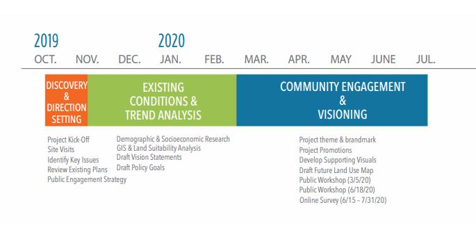
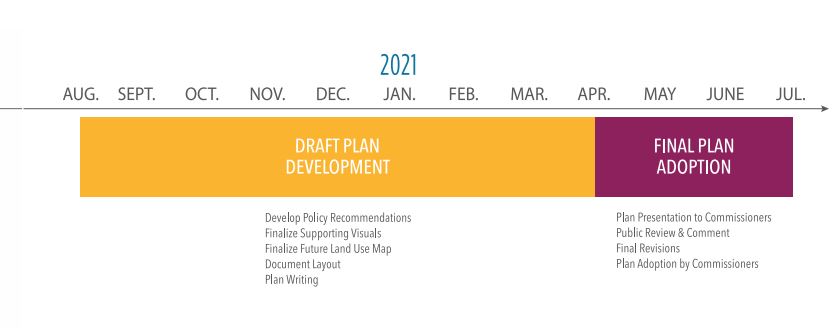
PLANNING PROCESS & TIMELINE
Mount Gilead Moving Ahead: Our Town 2040 was developed over the course of a five-phase process with the collaboration of town staff, town commissioners, the planning board, and community stakeholders.

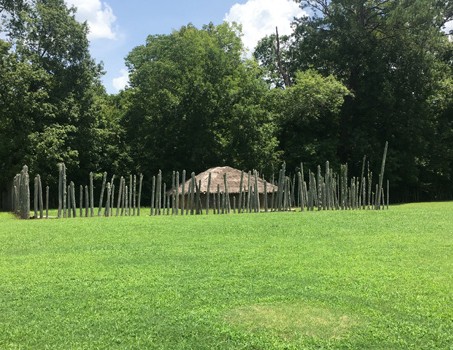
11th Century CE
PEE DEE INDIANS AT TOWN CREEK
The 11th century saw a new, distinct cultural tradition
emerge in the Pee Dee River Valley in present day North Carolina. The new indigenous culture,
called “Pee Dee” by archaeologists, gave rise to
multiple advanced societies. One such community
settled the area approximately 3.5 miles southeast
of present-day Mount Gilead at the confluence of
Town Creek and the Little River. The Pee Dee Indians
constructed an advanced community complex of
earthen mounds to host ceremonies and events
of spiritual and political importance. The Town
Creek community flourished in trade and craft, and
eventually moved to live with the Catawba Indians
prior to the arrival of European settlers. In 1937, the
Town Creek Indian Mounds became the first North
Carolina State Historic Site and one of the only state
historic sites dedicated to preserving indigenous
heritage. The Town pays homage to these first
inhabitants with a large mural
1790s – 1850s
PROVIDENCE SETTLEMENT
Present-day Mount Gilead was originally named
Scarborough Meeting House after the first settler of
European descent, William Scarborough, facilitated
the construction of a log-hewn Methodist church on
his land. Leaders of the First United Methodist Church
re-named their community Providence in 1820. The
post office was established in 1830 as the community
gained prominence from the construction of a road
linking Fayetteville to Salisbury that crossed through
the center of the Providence settlement. Tradesmen
and gold prospectors regularly traversed this road
and local farms prospered from their new-found
access to the large market city of Fayetteville.
This period also witnessed the establishment of
a prestigious private school called Edinborough
Academy in present-day Mount Gilead.

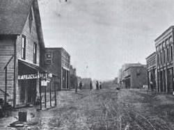
1855 – 1930
NEW CENTURY, NEW TOWN
In 1855, the community’s name changed again –
from Providence to Mount Gilead. Mount Gilead
was surveyed and platted in 1868, and officially
incorporated by the North Carolina General
Assembly in 1899.
The community grew steadily during this time
period, especially after completion of the railroad
through Montgomery County in the 1890s. Highly
accessible by both road and rail, the Town of Mount
Gilead experienced an economic boom as a regional
market town for cotton and produce. Numerous
businesses and industries strategically located along
rail and road corridors in the center of the town.
In the late 1920s, growing demand for electricity
spawned the construction of the Tillery Hydroelectric
Dam on the Pee Dee River. The hydroelectric plant
was put into service in 1928 and formed Lake Tillery
as it is known today.
The arrival of the Great Depression delivered a fatal
blow to the cotton industry, a fate inflicted on many
small towns across the Southeast. As cotton prices
fell steadily, farmers transitioned their fields to other
cash crops.
1930s – 1990s
TEXTILE TRANSITION
In the second half of the 20th century, cotton’s dominance was replaced by
textile manufacturing as the supporting pillar of Mount Gilead’s local economy.
In a way, cotton remained crucial to the Town’s well-being; but rather than
growing the raw material, textile mills sprouted up throughout town to process
it, many of them sock factories.
For sixty years, textile manufacturing was a prominent industrial sector across
the state. In the early1990s, textile companies shifted production to overseas
factories resulting in mass plant closings and layoffs throughout North Carolina.
Mount Gilead was not spared from this reality and many textile mills shuttered
their doors by start of the new millennium.
Despite economic ups and downs, this time period saw significant public
investment in the area including the construction of the Mount Gilead
Elementary and High Schools of which the auditorium and gymnasium remain
today. Most notably, President Kennedy established the Uwharrie National
Forest in 1961. Now a defining feature of the region, the 52,000-acre wilderness
with hills rising 1000 feet from the Yadkin & Pee Dee Rivers provides a source
for future economic vitality through recreation tourism.
Several notable Mount Gilead natives rose to prominence during the second
half of the century including former Lieutenant Governor from 1985-1989, the
late Robert B. Jordan III; and Julius Chambers, prominent civil rights attorney,
former NC Central University Chancellor, and first African American editor of
the law review at the University of North Carolina at Chapel Hill School of Law.
21ST Century
MOVING AHEAD
Following the exodus of textile mills, lumber and timber quickly emerged as
the primary engine of Mount Gilead’s economy, taking advantage of the area’s
plentiful supply of pine forests. Today, several wood-processing and forest product manufacturing companies call Mount Gilead home and employ over
one-third of the town’s workforce. One of the largest privately-owned timber
companies in the nation, Jordan Lumber, has been operating in Mount Gilead
since 1939. Nonetheless, a lack of service industry and professional careers has
resulted in a very slow but steady population decline as high school graduates
leave Mount Gilead for college or higher-paying jobs.
Despite this phenomenon, a shifting economic landscape and a resurgence in
community activism and investment in the downtown positions Mount Gilead
to capitalize on new opportunities for non-traditional economic development.
In an emerging economy where remote-workers can live anywhere, the town is
poised to leverage its charming downtown and proximity to Uwharrie National
Forest and Lake Tillery to attract a new wave of residents and visitors.
DEMOGRAPHIC & ECONOMIC TRENDS

This section presents a series of infographics that provide an objective and factual overview of pertinent demographic and socio-economic data to establish a baseline of existing conditions in Pilot Mountain and Surry County today. This data also signals trends that are affecting or will affect the community and future growth patterns.
POPULATION
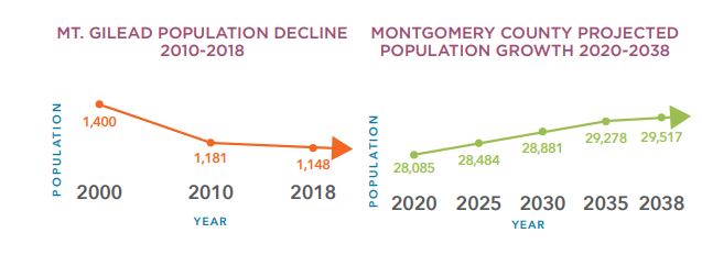
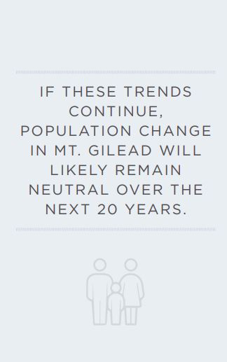
Mount Gilead has experienced very slow, but steady population loss over the past two decades at a rate of -2.8%. However, twenty-year population projections for Montgomery County indicate equally incremental, but consistent positive growth. The Piedmont Triad region as a whole is projected to add over 400,000 residents during the same time period (2020-2040). If these trends continue, population change in Mount Gilead will likely remain neutral over the next 20 years. However, the Town is poised to attract its fair share of new
residents if a concerted effort is put forth to invest in targeted infrastructure improvements
and new economic development initiatives.
COMMUNITY COMPOSITION
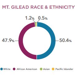
Mount Gilead enjoys a diverse population that is much less homogenous than surrounding Montgomery County and the state of North Carolina as a whole. The town’s population is roughly equal halves African American (47.9%) and Caucasian/White (50.4%). Mount Gilead is also home to a small, but established network of Laotian and Hmong families (1.2%).
AGE DISTRIBUTION
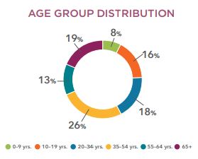
Age groups are fairly evenly distributed in Mount Gilead and consistent with age group composition for the state of North Carolina in general. The largest age group is 35-54 years old, representing 26% of the population. Mount Gilead’s slow population loss has occurred across all age groups rather than one singular age bracket.
HOUSING STOCK & OCCUPANCY
Approximately 79% of Mount Gilead’s housing
stock is occupied – a significantly higher
occupancy rate than Montgomery County at
62.7%.
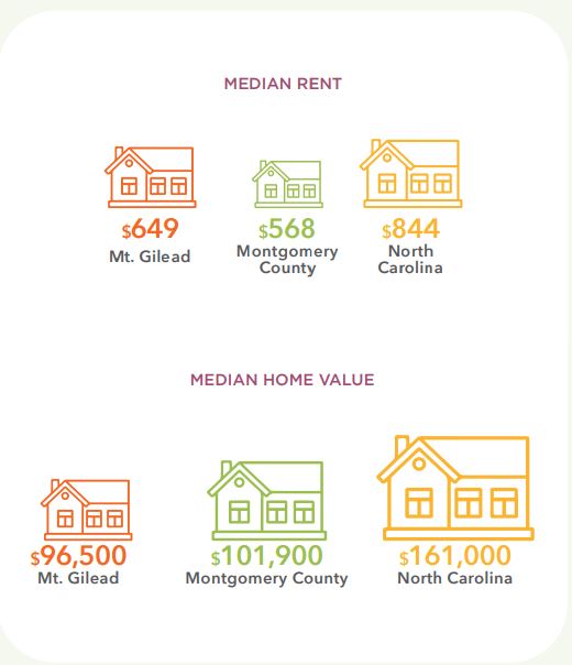
Mount Gilead’s housing stock is aging. Over half
of the Town’s housing stock is over 50 years old
(55.8%). High occupancy and aging housing
stock signal a shortage of quality, affordable
homes in absence of new construction.
Additionally, Mount Gilead’s home value is
under $100,000 and significantly lower than the
median home value of Montgomery County and
North Carolina.
COST BURDENED HOUSEHOLDS
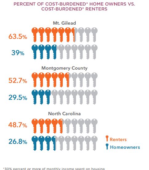
Thirty-nine percent (39%) of homeowners and
63.5% of renters in Mount Gilead are considered
cost-burdened by their housing, meaning that
they spend more than 30% of their monthly
income on housing and related costs such as
utilities. Both figures for Mount Gilead are well
above Montgomery County and North Carolina
rates for cost-burdened households and indicate
that rental housing is especially unaffordable for
most households in town.
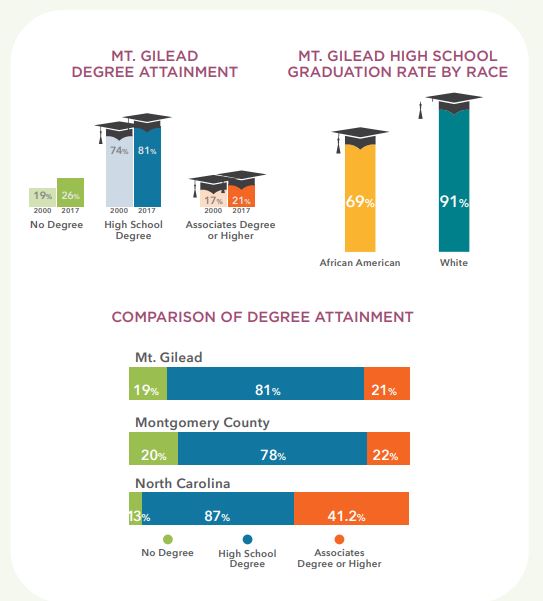
EDUCATIONAL ATTAINMENT
Educational attainment is a reliable indicator of
a population’s earning potential. Fortunately, in
Mount Gilead high school degree attainment has
increased 7% since 2000, and college degree
attainment (associates or higher) has increased
4% over the same time period. The number of
college graduates in both Mount Gilead (81%)
and Montgomery County (78%) lag far behind
the national average (41.2%).
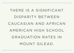
Additionally, there is a significant disparity
between Caucasian and African American
high school graduation rates in Mount Gilead.
Ninety-one percent of white students in Mount
Gilead graduate high school compared to 69%
of black or African American students. This 22%
differential is well above differences in graduation
rates at the county and national levels.
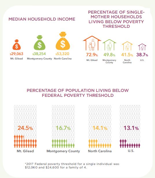
INCOME & EARNINGS
The median household income in Mount Gilead is
$29,063, almost $10,000 lower than the median income of Montgomery County ($38,254) and only about half as much as the median income of the state ($53,320). In considering that data, is it not surprising that Mount Gilead also has the highest percentage of residents living below the federal poverty threshold* (24.5%) as compared to national, state, and county rates. The poverty rate in Mount Gilead has increased six (6) percentage points since 2000. Nearly 73% of all single-mother households in Mount Gilead are struggling to survive under the poverty threshold – 23% more than in surrounding Montgomery County.
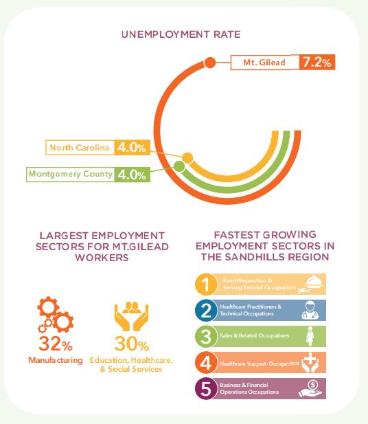
EMPLOYMENT
At 7.2%. Mount Gilead’s unemployment rate is also significantly higher than Montgomery County and the state of North Carolina (4%). The 2020 COVID-19 pandemic contributed to even higher rates of unemployment across the nation and in areas acutely affected by high infection rates, like Montgomery County. While the lasting economic impacts of the global pandemic are not yet fully understood, recovering the job losses that occurred during 2020 will take several years.
However, several job sectors in the Piedmont Sandhills region are growing; most notably in the food service & healthcare industries and sales. Currently, the largest employment sectors in Mount Gilead are manufacturing (32%) and education, healthcare, and social services (30%).

COMMUTE PATTERNS
Mount Gilead’s concentration of manufacturing
plants, many of which are supported by the lumber
industry, draws a significant number of workers to the
town every day. Three of Montgomery County’s top
ten employers are located in Mount Gilead: Jordan
Lumber, McRae Industries, and Mohawk). The Town’s
industrial sector brings in more daily workers (558)
than the number of residents who leave for work
(444). A very small proportion of the population both
lives and works in Mount Gilead (only 40 residents).
Top commute destinations for citizens who leave the
town for work are: (1) Mecklenburg; (2) Moore and; (3)
Randolph Counties.
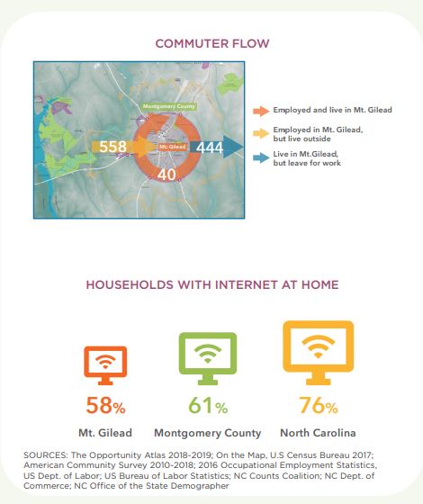
BROADBAND ACCESSIBILITY
Another factor that is likely linked to the disparity
in graduation rates, lower median salary, higher
unemployment, and higher poverty rates is availability
and access (or lackthereof) to broadband internet.
Only 58% of Mount Gilead households have internet
at home, compared to 61% in Montgomery County
and 76% in North Carolina. Forty-two percent of
the population does not have internet at home and
those without internet are disproportionately African
American households. Within the Mount Gilead
census tract that encompasses the town, 49% of the
Black population does not have access to internet at
home compared to only 33% of White households
that lack internet. Nonexistent or unreliable access
to the internet is a severe hindrance to educational
attainment and access to the highest paying jobs.
This digital divide was exacerbated by the COVID-19
pandemic as school closures forced students to learn
from home, leaving those without internet access at
high risk of falling behind.
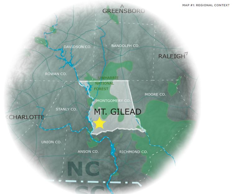
REGIONAL CONTEXT
The Town of Mount Gilead occupies 3.5 square miles in the southwest corner of
Montgomery County, NC. This area of the state is known as the Piedmont Sandhills
region. Mount Gilead is strategically located at the crossroads of NC Highways 731,
109 and 73 which connect the town to the interstate system, facilitating access to
metropolitan markets in Charlotte, the Triad, and the Triangle. The town, perched on
the edge of the Uwharrie National Forest, is rich in water-based natural resources. It is
located 3.5 miles east of the mighty Pee Dee River and Lake Tillery, a popular boating
destination. Mount Gilead enjoys the best of both worlds with easy access to both
urban centers and destination-quality outdoor recreation opportunities. These assets
present the Town with a significant opportunity to position itself for coordinated
growth and economic vitality
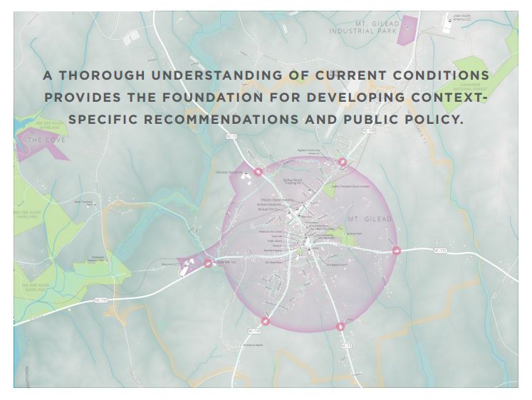
EXISTING CONDITIONS MAP SERIES
This following map series provides a geospatial presentation of the existing physical environment and development patterns within the Mount Gilead planning jurisdiction and surrounding area. Characteristics of the natural and built environment have significant implications for future land use, development policies, transportation networks, recreation opportunities, and open space preservation. A thorough understanding of current conditions provides the foundation for developing context specific recommendations and public policy that accounts for the nuances of Mount Gilead’s physical traits and historic growth patters.
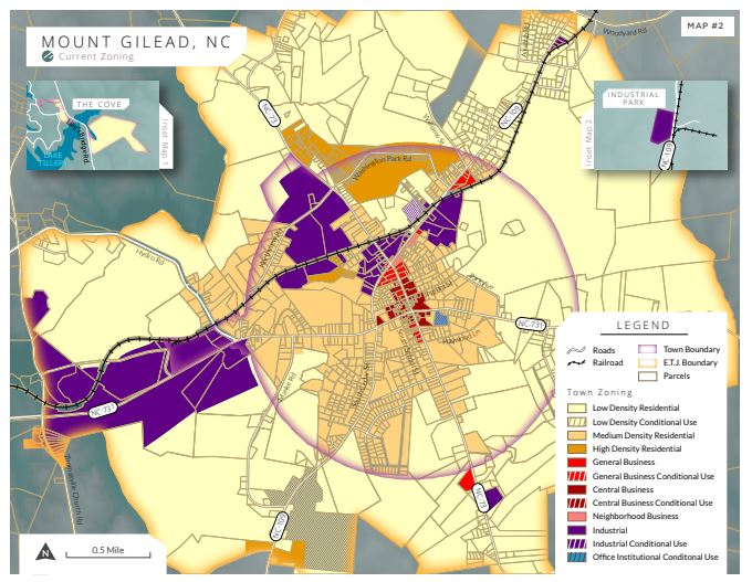
ZONING
The Mount Gilead zoning ordinance identifies nine (9) base districts, although two districts (Residential-Agricultural & Office-Institutional) have not yet been established on the zoning map for specific parcels. In addition, each of the 9 base zoning districts also has a corresponding overlay district to provide the Town discretion in establishing specific performance standards for a unique project. So far, five of the overlay districts
have been established on the zoning map for specific properties. In terms of residential and commercial uses, the zoning map and associated zoning regulations indicate a pattern traditional development that is denser in the Town’s core and becomes less-dense the further the distance from the core. While there is some mixing of compatible uses is allowed in each district, permitted uses predominantly follow a Euclidean-style of zoning with strong separation of uses into geographic districts.
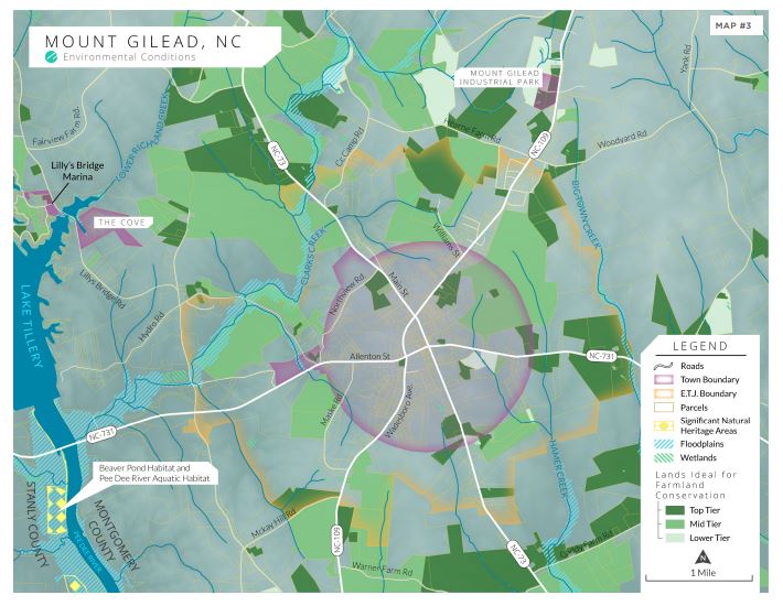
ENVIRONMENTAL CONDITIONS
Mount Gilead’s advantageous proximity to the Pee Dee River and its tributaries contribute to large swaths of top and mid-tier agricultural land as identified by the NC Natural Heritage Program’s Agricultural Lands Assessment which takes into consideration criteria developed by the USDA among other factors. Prime farmland and farmland of statewide importance play a critical role in the production of food, feeds, fibers, and oilseed crops. These farmlands have the ideal combination of physical and chemical characteristics for producing high yields year after year.
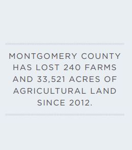
Farmlands comprise an integral part of open space, wildlife habitat, groundwater recharge areas, rural character and provide access to local food. Consistent with national and statewide trends, Montgomery county is experiencing a loss in farmland, with a 4% decrease in number of farms and acreage of farmland since 2012. Loss of prime agricultural lands puts added strain on less-optimal farmland that is less production. Conservation of Mount Gilead’s ideal farmlands will be paramount to preserving local food systems and the town’s rural residential nature.
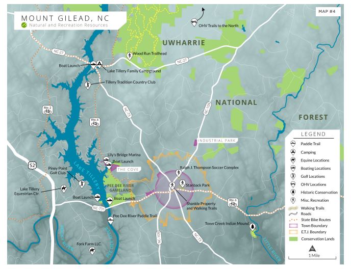
NATURAL AND RECREATION RESOURCES
Mount Gilead benefits from an abundance of natural and recreation resources in close proximity to the town. The most notable are Lake Tillery, the Pee Dee River, and the Uwharrie National Forest.
Lilly’s Bridge Marina, a satellite annexation to the Town of Mount Gilead, is a popular destination on the lake that provides boat storage, a lakeside restaurant, and even mini-golf. This area of the lake, less than 5 miles from downtown Mount Gilead, is home to the Pee Dee River Gameland and features a new public lake access area and boat launch managed by the NC Wildlife Resources Commission.
The Pee Dee River is located approximately 3 miles west of Mount Gilead. The 30- mile Pee Dee River Blueway begins here, south of the Tillery Dam and extends to Rockingham County. This paddle trail is part of the state-wide Carolina Thread Trail.
The 52,000 acre Uwharrie National Forest is 8 miles driving distance north of Mount Gilead and is a hub for outdoor recreation in the Piedmont. The forest offers miles of hiking, mountain biking, OHV, and equestrian trails in addition to camping, fishing, hunting, and a shooting range.
Within town limits, Mount Gilead offers three primary recreation destinations: Stanback Park, the Shankle property Walking Track, and the Ralph J. Thompson Soccer Complex. Stanback Park features several attractions including a pool and large playground. In the summer, Stanback Park hosts a popular youth day camp. It is owned and maintained by the Town along with the Walking Track. The Ralph J. Thompson Soccer Complex is privately owned and provides facilities for the local youth soccer program. The rural area surrounding Mount Gilead is also home to a handful of equestrian lodges and golf courses.
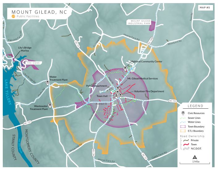
PUBLIC FACILITIES
Mount Gilead wastewater system came into operation in the 1940s. While the wastewater treatment plant is located just outside town limits, sewer line infrastructure is concentrated within town. The Town maintains more than 30 miles of sewer lines and the wastewater plant can treat up to 800,000 gallons per day, although the typically daily treatment load is 250,000 gallons. More than 90% of Mount Gilead’s residents are served by the town’s wastewater system. The Town continues to replace aging lines, although the pace of much-needed upgrades are slowed by the substantial cost. Mount Gilead has been successful in securing several grants over the couple of decades to assist with line replacement, but this ongoing effort will be a high priority for the foreseeable future.
The Town purchases treated Lake Tillery water from Montgomery County, but maintains its own water lines. The treatment capacity of Montgomery County’s water treatment plant is 6 million gallons of water per day and it currently provides about
3.9 million gallons of water to all five towns in the county, plus some rural areas. The majority of the Mount Gilead’s waterline infrastructure is concentrated within town limits, but several lines extend into the Town’s Extraterritorial Jurisdiction to serve development along major roads. The Town maintains more than 10 miles of lines and one 300,000-gallon elevated tank. More than 95% of Mount Gilead residents are served by the public water system.
Mount Gilead maintains nearly 11 miles of public streets, with the newest addition to the street system located in The Cove residential development, a satellite annexation located near Lake Tillery. The Town has made noticeable progress over the past decade in filling sidewalk gaps throughout town.
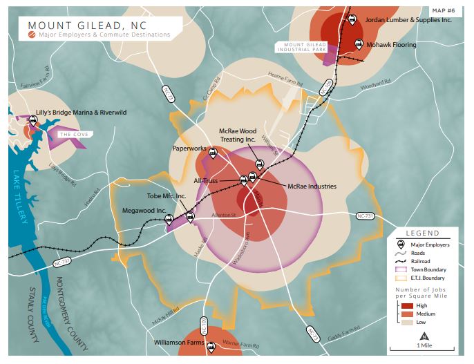
MAJOR EMPLOYERS & COMMUTE DESTINATIONS
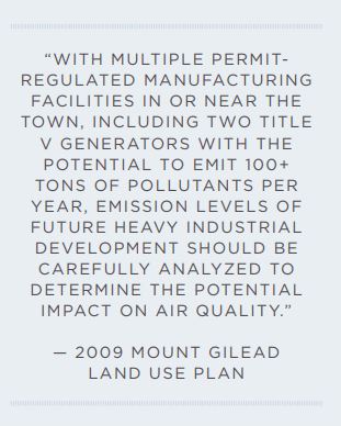
Several medium to large manufacturing companies, including three Title V facilities permitted by the NC Division of Air Quality at the highest allowable threshold for air pollutant emissions, are located in Mount Gilead.. Many of these plants are engaged in the production or processing of wood or paper products as a result of the area’s plentiful timber industry. Manufacturing employs over one-third of Mount Gilead population. The largest of these employers are identified on the adjacent map. The heat-map illustrates hot-spots for employment in Mount Gilead. Darker red areas have the highest concentration of jobs and are commute destinations for workers in Mount Gilead and surrounding counties.
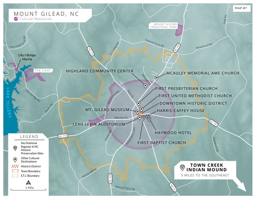
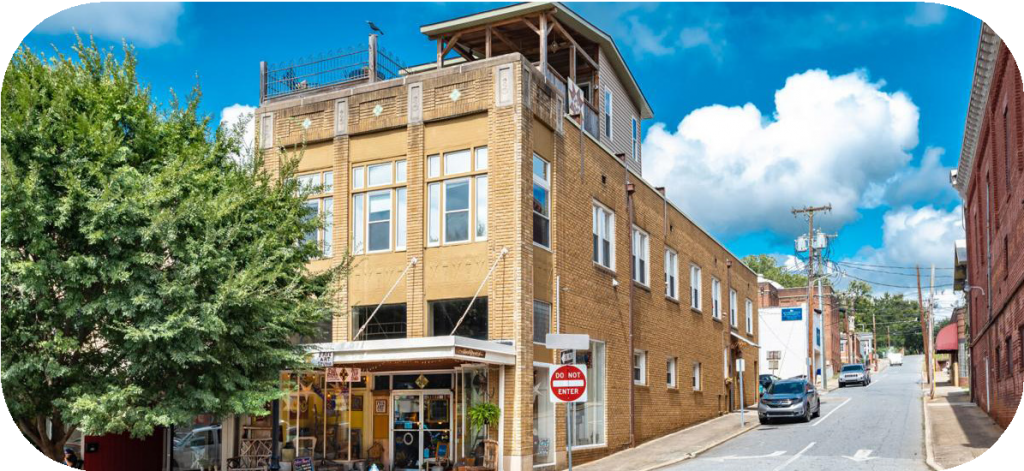
CULTURAL RESOURCES
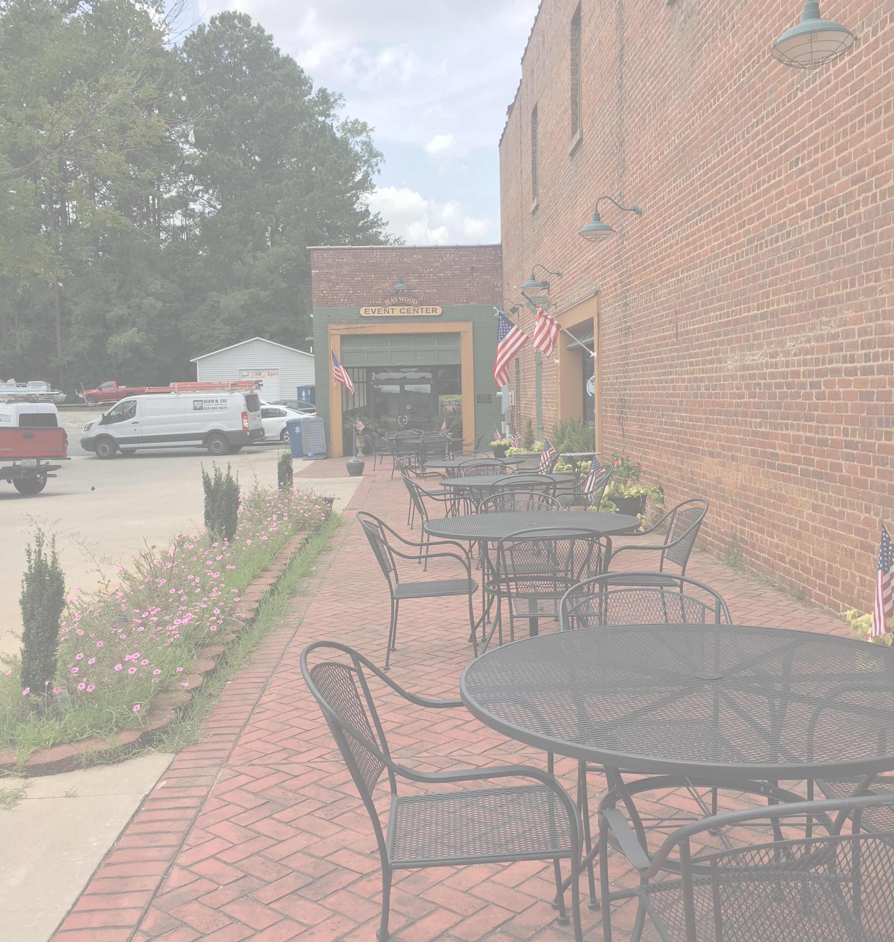
Much like its abundant natural assets, Mount Gilead is rich in history and cultural resources. Noteworthy cultural and community assets include the Downtown Historic District, Highland Community Center, and Town Creek Indian Mounds. Downtown Mount Gilead is a designated Local Historic District and has been on the National Register of Historic Places since 2005. The district includes 25 contributing buildings constructed in the Town’s central business district between 1900 and Notable architectural styles are Romanesque Revival, Gothic, Queen Anne, Mediterranean Revival, and Art Moderne. Highland Community Center is a fundamental community development organization in Mount Gilead. The community center occupies the campus of the former preintegration African American high school off of Julius Chambers Avenue. The community center, its board of directors, and volunteers operate several important programs that serve the Mount Gilead community at large, including programs for seniors, mentoring programs for youth, and continuing education for high school equivalency diplomas in partnership with Montgomery County Community College. Highland Community Center is an active and productive organization that is highly responsive to meet urgent community needs. In response job losses and economic challenges presented by the Covid-19 Pandemic, Highland quickly organized regular
drive-through food donation pick-ups for families in need. In addition, the community center offers ball fields for recreation and rents its facilities for meetings and events. Town Creek Indian Mound State Historic Site, located 3.5 miles southeast of Mount Gilead at the confluence of Town Creek and the Little River, is one of the most
archaeologically significant sites in North Carolina. The site preserves 11th century Pee Dee indigenous culture through re-constructed mounds and structures, and includes an interpretive center on site. Town Creek Indian mound attracts more than 20,000 visitors per year.
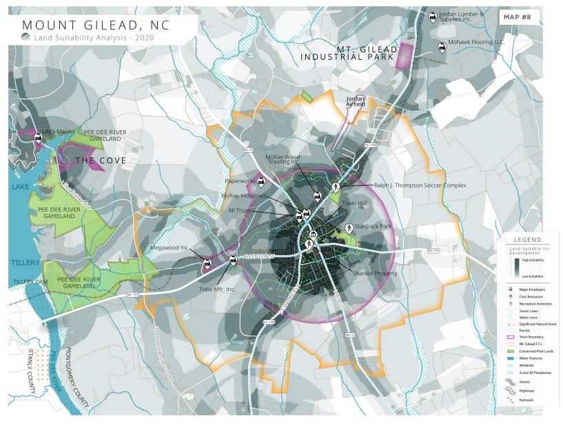
LAND SUITABILITY ANALYSIS
The Land Suitability Analysis (LSA) combines the data sets presented in the previous map series into a single geo-spatial model that evaluates and classifies land on a spectrum of most to least suitable for new development. The LSA model takes into consideration several factors, including:
» Existing development status (developed or undeveloped)
» Proximity to public infrastructure (roads, water, sewer, rail, sidewalks, existing & proposed greenways
» Proximity to cultural & recreation amenities, schools, and major employers
» Environmental factors (floodplain, wetlands, and prime agricultural lands)
High suitability land is located outside of environmental hazard areas, is not characterized as prime agricultural land, and is located near existing development and public infrastructure. Low suitability lands are less appropriate for development due to environmental constraints and distance from existing infrastructure.
The LSA provides a broad analysis of existing data and is only one of several considerations used to determine the appropriateness of development for a tract of land. The LSA presents a general snapshot of areas most suitable for development, while highlighting areas that are best suited for conservation. It does not account for site and project-specific factors that must be also be considered on a case by case basis.
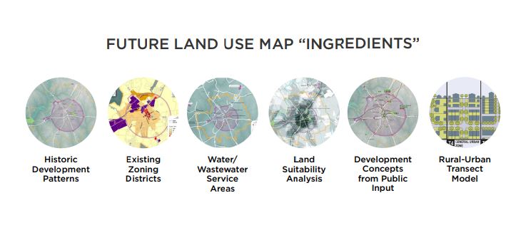
The LSA is one of several valuable tools used to develop the Future Land Use Map. Other factors that inform future land use are historic development trends, existing land use policies and infrastructure, community preferences, and professional land planning methodologies.
For a complete list of factors and more details on the LSA methodology, see Appendix A
INFLUENTIAL PLANS & STUDIES
Mount Gilead and the Piedmont Triad Region have a strong history of long-range planning and documented community initiatives. This section summarizes key recommendations from pertinent plans and studies. Mount Gilead Moving Ahead builds upon these previous planning efforts and incorporates relevant recommendations where appropriate.
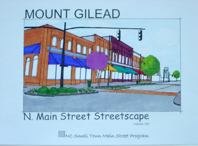
2007 Mt. Gilead Downtown Streetscape Improvements
» Offers human-scale landscape improvements in Mt. Gilead Downtown area
» Suggests layout changes and design elements at Mt. Gilead Post Office and
Hayford-Ford Restaurant
» Set of plan drawings recommend streetscape improvements along N. Main Street and W. Allenton
to facilitate harmonious coexistence of vehicles and pedestrians while making the area a hub of
community connectivity .
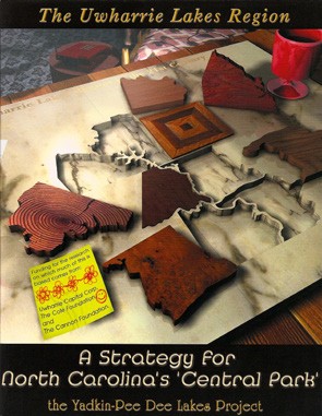
North Carolina “Central Parks” Plan
» Montgomery County is part of 7-county Uwharrie Lakes Region
» Promotes use of sustainable recreation and tourism for economic growth
» Develops marketing strategy which suggests preservation of cultural and natural heritage sites while
supporting small business development
» Supports planning for future development of small towns within the Uwharrie Lakes region
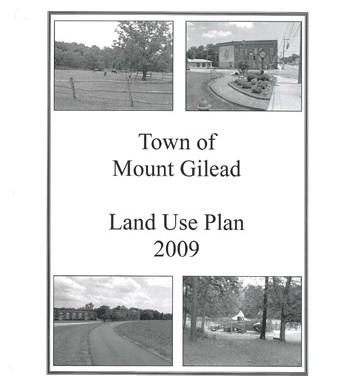
2009 Town of Mt. Gilead Comprehensive Land Use Plan
» Encourages planning for walkability, beautification through landscaping design, and supporting a variety of
housing types
» Suggests mixed use development in the downtown area while preserving its historic character
» Develop a long-term improvement plan for Stanback Park, as well as promoting recreational
facilities and programming throughout the area
» Expand and maintain transportation, water, and sewer infrastructure as Mt. Gilead grows
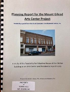
2010 Planning Report for the Mt. Gilead Arts Center Project
» Adaptive reuse of the McRae building as a multi-use arts center with apartments
» Ground floor renovation to adapt unused spaces into an art gallery and public
studio/classrooms
» Second floor’s open space allows for flexibility in designing multiple residential units
» Suggests this creation of desirable and functional spaces will encourage community engagement
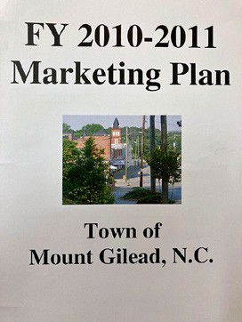
FY 2010-2011 Town of Mt. Gilead Marketing Plan
» Outlines ways for town leaders to ensure Mt. Gilead’s continuing
economic development
» Public survey indicates focus on youth engagement and population retention
» Recommends growth of the Mt. Gilead Youth Council to encourage early
engagement in civic service
» Recommends establishing a variety of community making techniques such as
local newsletters, updated website, art festivals, and community events to attract young families and
businesses.
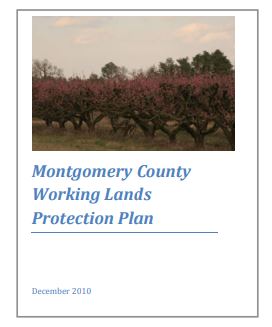
2010 Montgomery County Working Lands Protection Plan
» Analysis of agricultural lands throughout the county with focus on the
major components of the forestry industry
» Recommends establishing local food cooperatives and farmer’s markets
highlighting county agriculture
» Suggests engaging public with local agriculture through
various organizations; an Agricultural Biotechnology Advocacy Action team,
Local Forestry Association Club, Agricultural Education program, and Agritourism
destinations website.
Mt. Gilead Historic Preservation Commission: Historic District Guidelines
» Downtown Mt. Gilead is listed in the National Register of Historic Places
and has been locally designated as a Local Historic District
» Establishes procedure for changes of the built environment within the
designated Historic District
» Takes into account preservation, reconstruction, and addition
of new design for various architectural elements
» Details procedure for retrofitting buildings for ADA-compliant accessibility
and sustainable energy systems
Montgomery County RCATS Community Transportation Services Report
» Regional Coordinated Area Transportation System (RCATS) connects
Randolph and Montgomery counties
» Assesses RCATS Management, Service, and Coordination with other
services
» Offers five-year Development, Capital, and Operating plans
» Considers connection with local transportation systems, increasing use of
scheduling software, replace and update aging vehicles, and anticipation of future
budget changes
2011 Piedmont Triad Regional Trail Plan and Inventory
» Inventories existing and proposed trails throughout the region
» Identifies new proposed connections to help create a regional trail system
» Highlights the importance of local governments to adopt the plan and
participate in local efforts to enhance existing trails and develop new regionally
connective sections
2012 Montgomery County Comprehensive Transportation Plan & 2018 Update
» Long range multi-modal transportation plan covers transportation needs
through 2040
» Highway improvements include widening, conversion to divided expressways, and other
specified changes for 8 specific highway areas
» Public Transportation recommendations suggest more flexible service of the RCATS along with addition
of Park-and-Ride lots
» Bicycle recommendations include new local trails as well as connector routes
» Pedestrian recommendations suggest improvements for aging sidewalks and development
of new sidewalks along major roads for individual towns within the county
20-Year Capital Improvement Plan Fiscal Year 2015-2016 Update
» Identifies major issues in the water and sewage system including material age and
wear as well as inadequate service to residents
» Recommends creation of forward-facing plan to budget for replacement and
rehabilitation of aging and undersized water lines.
» Establishing said scheduled plan allows the town to streamline financing and
ensure construction of updates to sewer and water system issues.
2018 Mt. Gilead Main Street Recommendations Report
» Analysis of two-day workshop in which local stakeholders discuss opportunities for economic
growth.
» Recommends development of comprehensive Mt. Gilead master plan
» Suggests plan should focus on enhancing the downtown experience while preserving historic
infrastructure, building improvements for the Highland Community Center, and rezoning and
revitalizing the RussellHarvell Mill for mixed use.
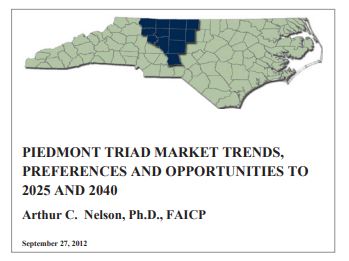
Piedmont Triad Market Trends, Preferences and Opportunities 2025 to 2040
» Analyzes trends in growth of the counties making up the Piedmont Triad region
» Market trends and preference surveys are used to estimate demand for specific types of
development including mixed use housing and walkable communities
» Recommends accommodating anticipated growth by retrofitting suburban commercial
corridors
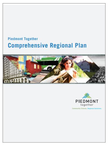
Piedmont Together Comprehensive Regional Plan
» Highlights equitable solutions to regional issues and offers suggestions for a variety of planning
areas; jobs, housing, transportation, healthy communities
» Calls to expand housing choices for all by revitalizing development through infill, promoting mixed income
housing, and converting foreclosures into new assets
» Ensure transit infrastructure exists to provide multiple affordable modes of travel across and within the region
as well as maintaining the region’s freight transportation system
» Build on the region’s economy by identifying and supporting emerging industry clusters and investing in the untapped human capital of the region
» Envisions healthy communities throughout the region that support active lifestyles with access to recreation, safe pedestrian environments, and local food distribution
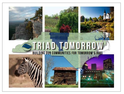
Triad Tomorrow: Comprehensive Economic Development Strategy
» Focuses on four broad goals for the region to enhance economic growth
» Build on the region’s competitive advantages and leverage the marketplace by
targeting existing growth clusters
» Establish and maintain regional infrastructure of highways, railways, air
services, and increasing interregional public transit options.
» Support individual communities by ensuring the health of small businesses, local farmers,
and retrofitting towns for pedestrian access
» Develop innovative workforce by supporting educational attainment, encouraging civic
engagement, and technical training
2020 Montgomery County Marketing & Tourism Assessment
» Develops a set of strategic marketing recommendations for Montgomery County
» Identifies the county’s top assets to feature in marketing; historic downtowns, natural
landscapes, regional and small town events
» Suggests establishing a unique visual brand designed around the Uwharries, launching a
tourism website, and using local resident and visitor stories for marketing.
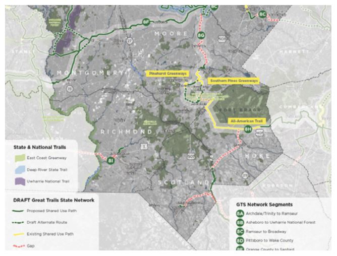
Great Trails State Plan, NCDOT Division 8
» Identifies a conceptual regional network of planned interconnected trails and greenways
» Route 8F is proposed as a multi-use path through Mount Gilead
» Route 8F would connect the Uwharrie National Forest to Chatham County and subsequently link Mount
Gilead the Town of Troy
» Detailed planning at the local level will be required to further evaluate route feasibility
Other Significant Plans, Studies, & Policy Documents
» Mount Gilead Zoning Ordinance » Piedmont Triad Regional Open Space Strategy, 2003 » Mount Gilead Historic District National Register of Historic Places Application, 2005 » Piedmont Triad RPO Regional Bicycle Study, 2005 » Piedmont Triad RPO Scenic Byways Screening Study, 2007 | » Town of Mount Gilead Annexation Strategic Report, 2010 » Interstate 73/74 Economic Atlas of North Carolina, 2011 » Piedmont Triad Land Supply Analysis, 2011 » Uwharrie National Forest Land & Resource Management Plan, 2012 | » Piedmont Together: Green Infrastructure Network Strategy, 2014 » Piedmont Together: Planning for the Energy Future, 2014 » Piedmont Together: Equity Report, 2014 » Piedmont Triad Environmental Justice Scan, 2016 » Piedmont Climate Resiliency Toolkit, 2018 |
ENGAGEMENT STRATEGY
Public engagement is at the heart of a successful planning process. Purposeful and sincere community outreach is critical to cultivating public trust, expanding support for the plan, addressing concerns early in the process,
and building a sense of ownership for plan implementation. Town staff, the Planning Board, and Town Commissioners guided plan preparation with local perspective and insight. They were also critical in generating community participation through traditional and digital approaches to public engagement. Outreach strategies for Mount Gilead Moving Ahead included public workshops and an online survey. Details and results are provided on the following pages. (For more detail on public engagement results, see Appendix B)..
SPREADING THE WORD
A concerted project promotional campaign utilized both print and digital media to raise awareness for the project and encourage participation at public engagement events.
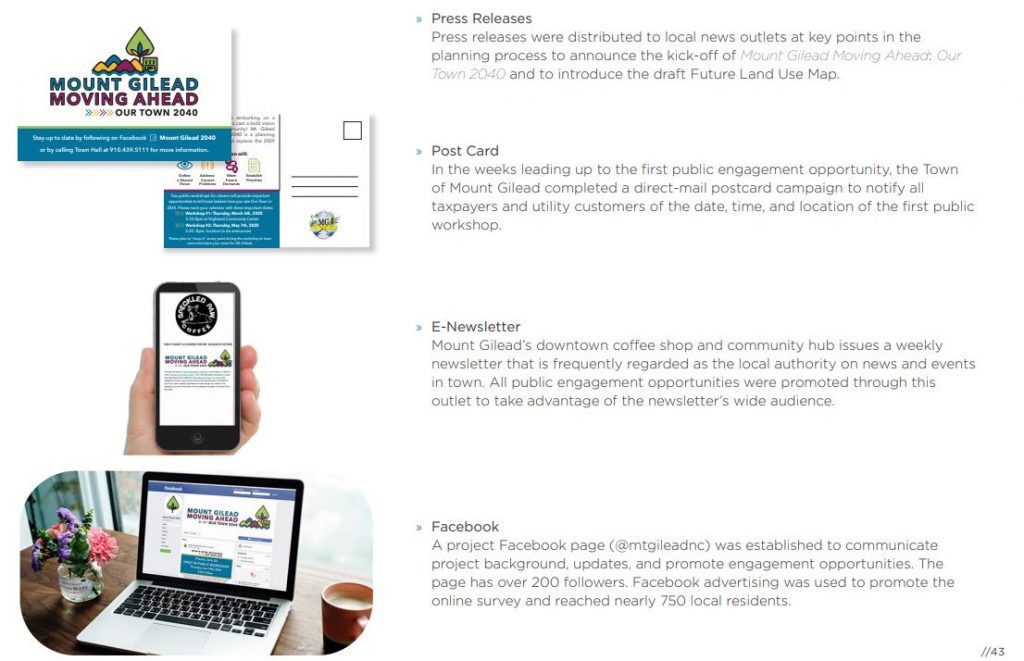
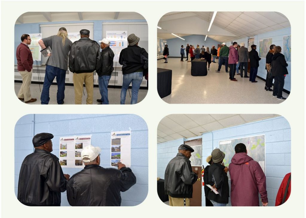
PUBLIC WORKSHOPS
Two (2) public workshops were hosted in the spring of 2020. Both workshops were drop-in style open houses that provided attendees to review information on existing conditions; communicate their vision for Mount Gilead; and respond to future land use policy and conceptual visualizations.
WORKSHOP #1
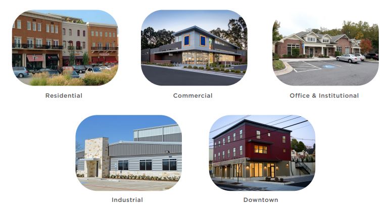
Mount Gilead Moving Ahead’s first workshop was held on the evening of March 5th, 2020 at Highland Community Center. The first workshop presented an introduction to comprehensive planning; provided results of the existing conditions & emerging trends analysis; and solicited feedback on community preferences and priorities. It was attended by approximately thirty (30) community members who rotated through a series of stations including:
» Plan Background & Introduction
» Learning Station that presented the infographics and Land Suitability Analysis
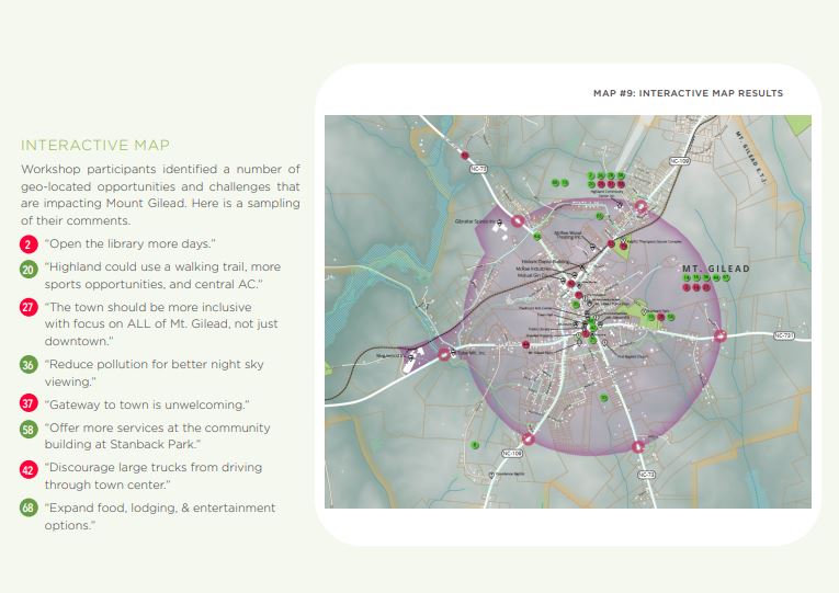
» Interactive Map Activity that allowed participants to map opportunities and challenges faced by Mount Gilead
» Visual Preference Survey where citizens could indicate their preference for different types of residential, commercial, downtown, office, institutional, and industrial development by voting on images
WORKSHOP #1 RESULTS
Results of the Visual Preference Survey indicated a strong desire for upper-story residential in downtown and communicated the types of building form, site design, and architectural styles preferred for commercial, office, and industrial uses. The following images are representative of the community’s desired look and feel for the built environment.
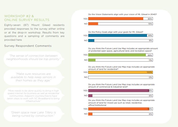
WORKSHOP #2 & ONLINE SURVEY
In response to the global COVID-19 pandemic, the second phase of public engagement was modified to provide for healthy and safety without diminishing opportunities for participation. An online survey option was added and the drop-in workshop was reformatted to follow all CDC guidelines and reduce the interaction between
participants. The workshop took place on the evening of June 18th, 2020. The online survey was available from June 15th through July 31st, 2020. The online survey and drop-in workshop featured identical content and questions. Both tools presented and solicited feedback on the following:
» Draft Vision Statements
» Preliminary Policy Goals
» Draft Future Land Use Map
» Conceptual Supporting Visuals

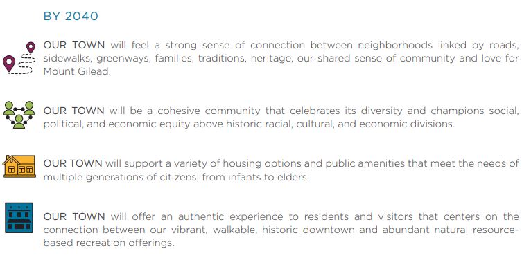
COMMUNITY VISION STATEMENTS
Valuable insights and ideas gleaned from the community directly influenced the development of Community Vision Statements that articulate a collective future vision for Mount Gilead. The Vision Statements provide the overarching framework for public policy goals and plan recommendations.
CHAPTER OVERVIEW AND USER GUIDE
This chapter identifies recommendations that will guide Mount Gilead leaders and the community at large to achieve the prosperous future identified in the Vision Statements in the previous chapter.
These recommendations are informed by data-driven research, professional best practices, and the rich set of community values that were communicated through the public engagement phase. Collectively, these strategies represent a wide range of tools, resources, and public policy necessary to meet Mount Gilead’s existing challenges, future demands, and desired outcomes.
1. MOUNT GILEAD BOARD OF COMMISSIONERS
Mount Gilead Moving Ahead: Our Town 2040 serves as a policy and decision-making guide for the Board of Commissioners on matters related to land use and development, economic development, transportation, recreation, and placemaking. The goals, policies, and Future Land Use map will guide decisions on the Town’s ordinances and regulations.
2. PLANNING BOARD
The Planning Board will use Mount Gilead Moving Ahead to determine consistency of development proposals and plans with the goals, policies, and recommendations stated in this plan. Consistency with Mount Gilead Moving Ahead should be the primary basis for deciding to grant or deny any request heard by the Planning Board.
3. TOWN STAFF
This plan will guide Mount Gilead town staff in evaluating development proposals, prioritizing projects, and initiating code amendments. Staff will use the plan when preparing its budget recommendations, grant applications, and pursuing partnerships.
Town planning staff should annually review Mount Gilead Moving Ahead and update the plan at least every five (5) years to reflect completed actions and incorporate new opportunities or challenges.
4. PROPERTY OWNERS + DEVELOPERS
The goals, policies, and Future Land Use Map in Mount Gilead Moving Ahead communicate the types and locations of land uses and development that are desired by the Town. Policies, recommendations, and the Future Land Use Map will help property owners understand what uses and development types may be appropriate for their property and allow them to formulate development proposals that are consistent with the shared vision set forth in this plan. In addition, the plan points to basic sources of information that will help owners and developers understand the capabilities and limitations of their property.
5. COMMUNITY ORGANIZATIONS AND ADVOCATES
Mount Gilead has a strong history of grassroots community leadership that have been responsible for spearheading many community development initiatives over the years. Mount Gilead Moving Ahead identifies several projects that could be led by local community organizations and agencies working in tandem with the Town.
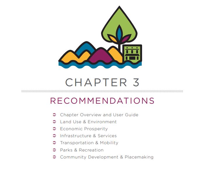
This plan provides recommendations according to six (6) planning elements:
- Land Use & Environment
- Economic Prosperity
- Infrastructure and Services
- Transportation & Mobility
- Parks & Recreation
- Community Development & Placemaking
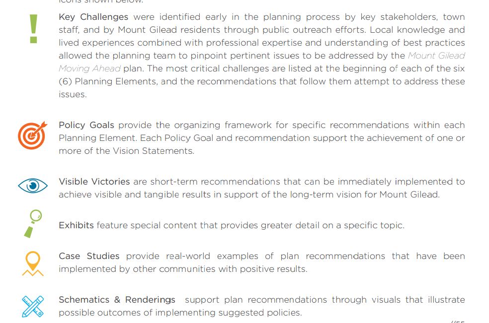
Each Planning Element contains the following special features that organize and support plan
recommendations: Special Features are identified throughout the chapter by the associated
icons shown below.
PLANNING ELEMENTS
LAND USE & ENVIRONMENT
KEY CHALLENGES
» Lack of new workforce housing
» Protection of existing neighborhood and rural character
» Development encroachment surrounding Lake Tillery
VISION STATEMENTS
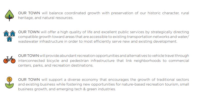
-OUR TOWN will support a variety of housing options and public amenities that meet the needs of multiple generations of citizens, from infants to elders.
-OUR TOWN will balance coordinated growth with preservation of our historic character, rural heritage, and
natural resources.
-OUR TOWN will offer a high quality of life and excellent public services by strategically directing compatible growth toward areas that are accessible to existing transportation networks and water/wastewater infrastructure in order to most efficiently serve new and existing development.
Unlike so many other small towns across the country, Mount Gilead has successfully avoided succumbing to suburban patterns of development characterized by strip shopping centers, massive parking lots, and mass
conversion of farmland into large-lot subdivisions. Instead, Mount Gilead exhibits a well-preserved traditional development pattern with a historic downtown core surrounded by established neighborhoods and a modest commercial & industrial area that gives way to a greenbelt of pastoral landscapes on the edge of town. This
preserved traditional pattern of development is something that sets Mount Gilead apart and now is the time to protect it from sprawling auto-oriented development that requires extensive infrastructure investments. While enticing, that kind of development produces only short-term prosperity in exchange for a hefty long-term
maintenance burden on the town.
FUTURE LAND USE FRAMEWORK
Mount Gilead’s framework for future land use is comprised of two components: the Rural-Urban Transect and the Future Land Use Map. This framework serves as the cornerstone of the plan, providing guidance to Mount Gilead’s municipal leaders as they make land use development decisions that direct where and how the community will grow.
RURAL-URBAN TRANSECT
SCHEMATIC #1: Mount Gilead Future Land Use Transect
The Rural-Urban Transect* is a land use planning methodology that presents a cross-section of the landscape from rural outerlands to a more urbanized core, and relates development potential to the ecological conditions and human settlement patterns of the land.
The transect establishes a spectrum of land classification for both the environmental and built character of the Town’s planning jurisdiction. This allows for the most efficient provision of municipal services and tax-base stability. Growth and conservation are coordinated to ensure that development happens in a fiscally- responsible way. In applying the transect model to Mt. Gilead’s Future Land Use Map, the composition of the map is heavily determined by the location of existing infrastructure (roads, water, sewer) and the presence or absence of existing development to inform what the future land use should be in any given area.
The Rural-Urban transect presented here has been adapted for Mount Gilead’s specific environmental context, historic development pattern, and desired land uses. Mt. Gilead’s historic growth pattern is largely consistent with the Rural-Urban Transect and traditional small-town growth. The Town has grown slowly outward from the downtown with minimal residential sprawl and a surrounding green belt of agricultural land. The transect model and future land use map promote the preservation of this beneficial historic pattern of development so that Mt. Gilead can retain its unique rural character and small-town charm while avoiding sprawling development patterns that result in loss of agricultural lands and costly provision of services.
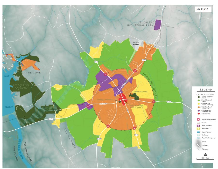
The Mount Gilead Transect classifies land into six sectors:
- Rural Conserved Lands
- Rural Reserved Lands
- Low Density Rural Community
- Neighborhood Mixed-Use
- Commercial/Industrial Mix
- Town Center
The Sectors allow for more than one kind of use and align with traditional small town development in which residential and compatible non-residential uses coexist together. Appropriate levels of mixed-use provide more locations for housing that is affordable, walkable, and provides convenient access to essential
commercial needs like groceries, pharmacies, and retail.
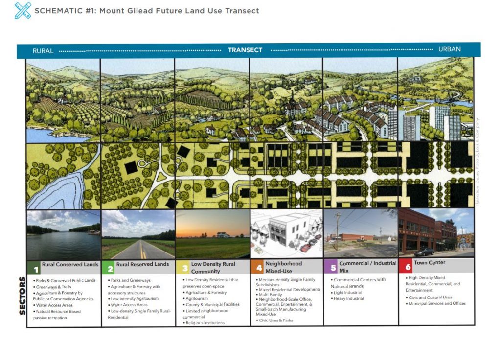
*Originally developed by Duany Plater-Zyberk & Company and the Center for Applied Transect Studies
HOW TO USE THE FUTURE LAND USE MAP
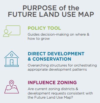
The Future Land Use Map is a policy tool (in contrast with the zoning map which is a regulatory tool). It is intended to guide Mount Gilead’s appointed and elected leaders as they make decisions on where and how the community should grow.
This map provides the overarching structure for orchestrating appropriate patterns of development and conservation throughout Mount Gilead’s jurisdictional territory. The Future Land Use Map should influence and inform the Town’s zoning as a way to achieve desired growth patterns.
Consideration of specific development requests such as Re-zonings, Conditional Zoning Districts, or Conditional Uses should include a study of the Future Land Use Map to determine whether the request is consistent with the future land use policy vision. The Future Land Use Map can also serve as the impetus for Town-initiated amendments that make the zoning map more consistent with desired future land use.
The following pages provide a sector-by-sector presentation of the Future Land Use Map. Each map builds upon the previous map to compose the official Future Land Use Map of Mount Gilead, North Carolina.
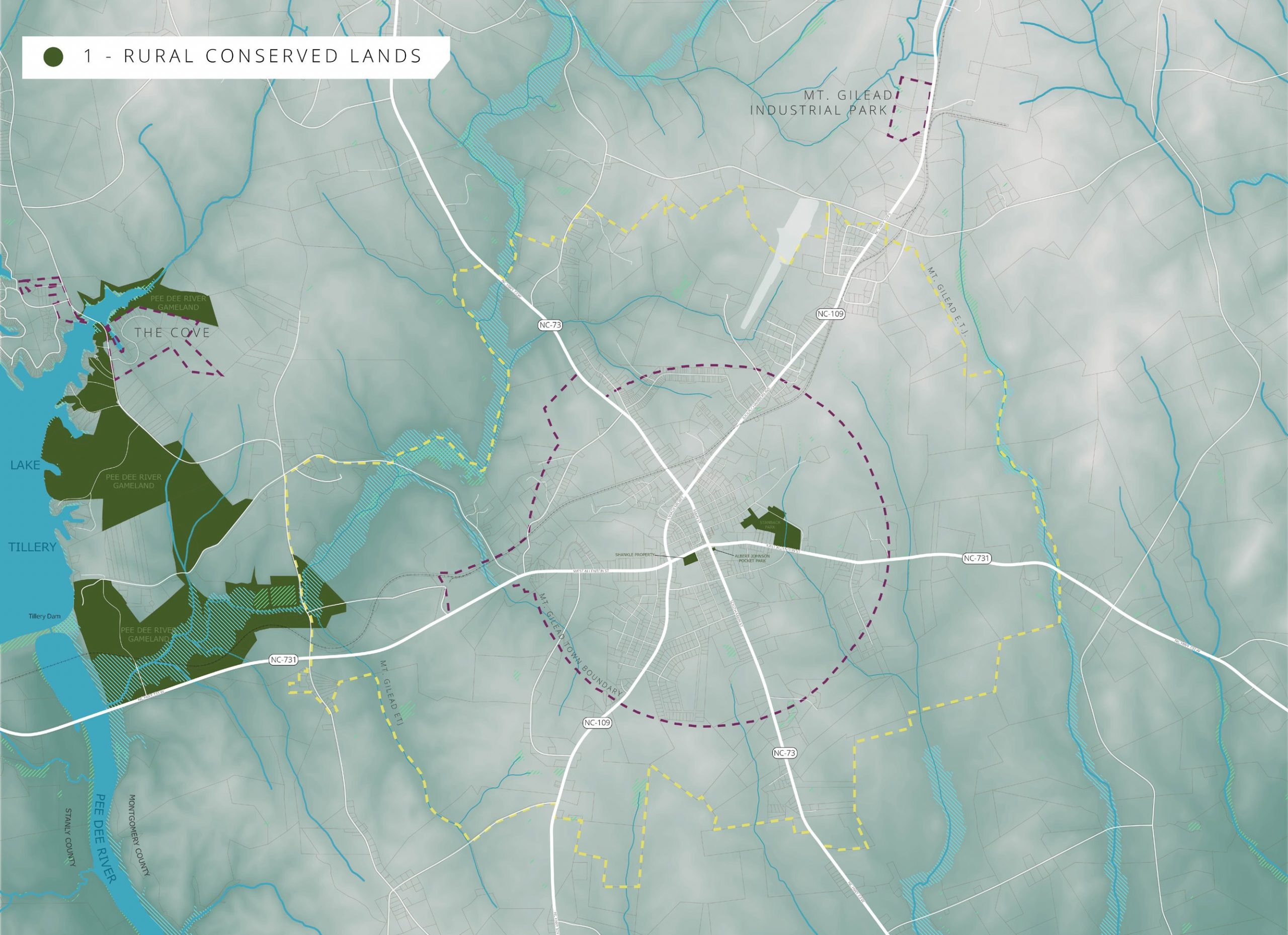
Sector 1: RURAL CONSERVED LANDS
Sector 1 is comprised of nature preserves, conservation lands, and Town parks. This sector includes existing major conservation lands under the control of government or private conservation agencies. Many of these lands provide educational, ecotourism, or passive recreation opportunities. This category, indicated in dark green on the Future Land Use Map, comprises lands that are primarily undevelopable, such as swamps, wetlands, riparian buffers, and parks.
Appropriate Land Uses and Development Types:
» Parks and Public Lands
» Greenways & Trails
» Public water-access facilities
» Natural-resource based passive recreation
» Forestry and agricultural practices related to land-management by conservation and public agencies
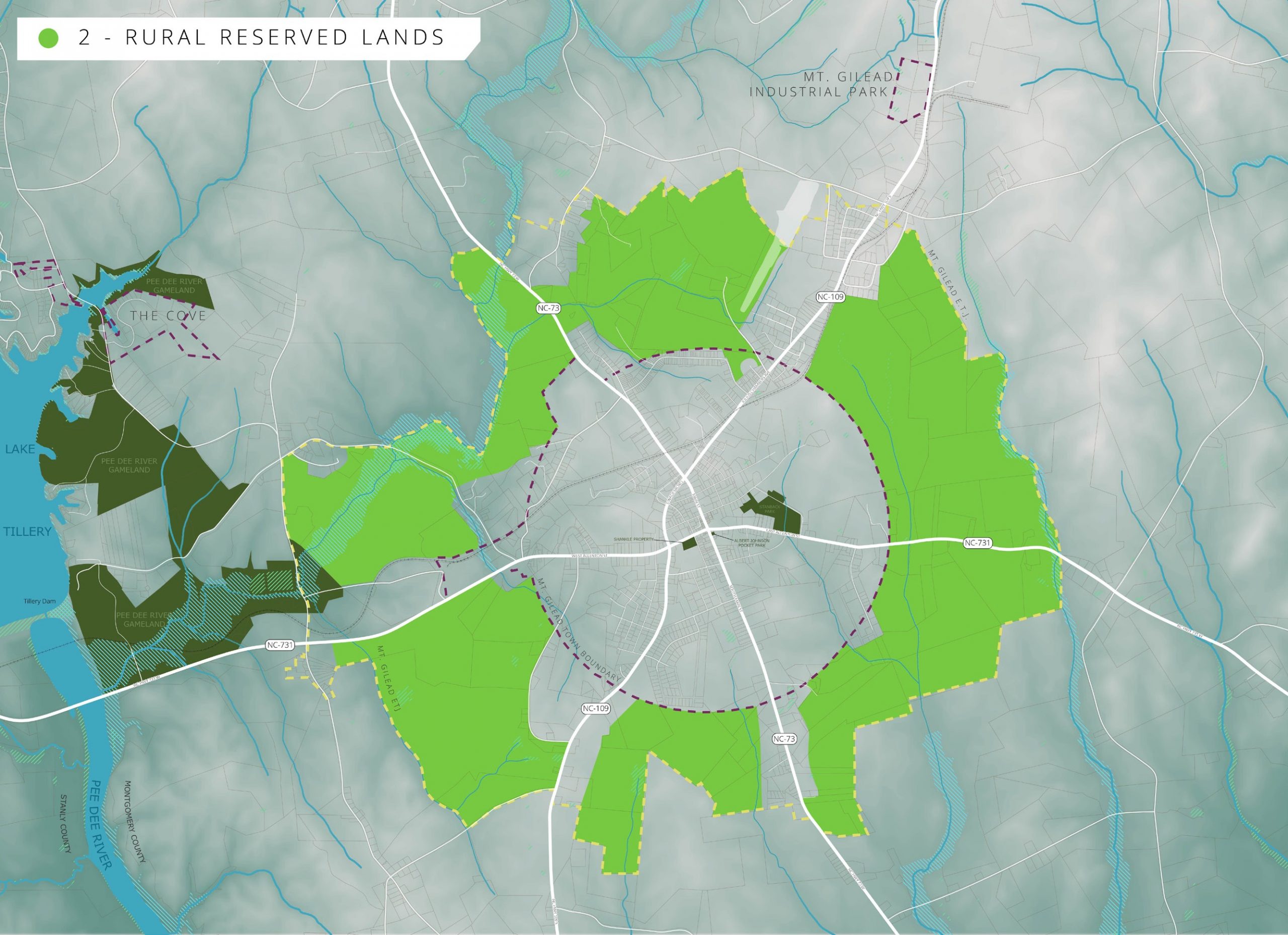
Sector 2: RURAL RESERVED LANDS
Sector 2 is comprised of wetlands, environmentally sensitive areas, significant natural heritage areas, sensitive habitat areas, and high-quality agricultural lands that should be targeted for farmland preservation or general conservation. Sector 2 classification also allows for limited development of low-density single family residential. This area should not be targeted for expansion of public or private water and sewer infrastructure. Some areas located within Sector 2 zones could ultimately transition into Sector 1 by expanding public lands and preserving highly sensitive natural resources and riparian areas.
The preservation of environmentally significant rural areas accomplishes many planning goals:
» It discourages sprawl by focusing new growth in and around existing developed areas.
» It plays an important role in natural resource protection.
» It promotes fiscal stewardship by encouraging growth within the municipality for a more efficient use of public facilities and existing infrastructure.
Appropriate Land Uses and Development Types:
» Public water access and related amenities
» Parks & Greenways
» Forestry
» Cultivated farm and timberland with accessory agricultural structures; low- intensity agritourism
» Very Low-density single family rural-residential that maintains preservation of open space and natural landscapes
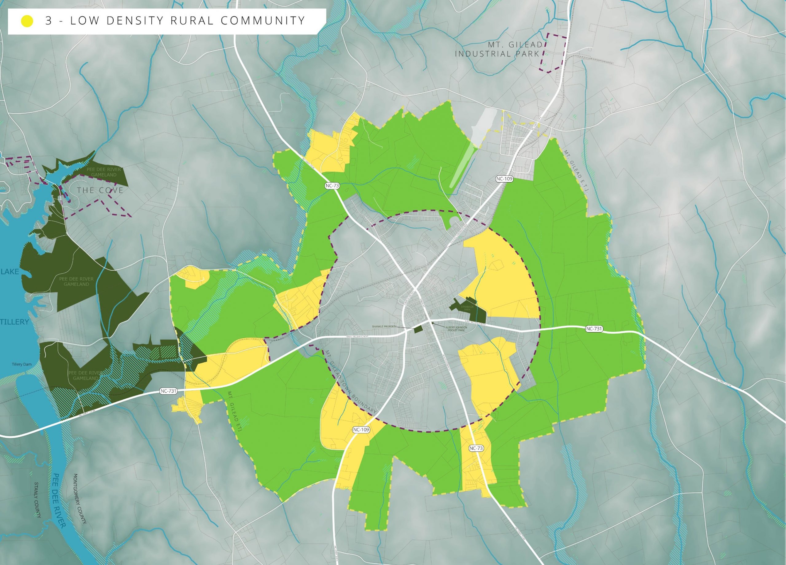
Sector 3: LOW DENSITY RURAL COMMUNITY
Sector 3 is intended for agricultural lands and compatible low-density rural residential growth that may be supported by limited small-scale neighborhood retail. Residential and non-residential uses should be in keeping with community character. Desirable development in this sector typically consists of cluster development such as conservation subdivisions, or low-density residential development on larger lots.
Limited municipal services, such as fire protection, emergency services, and public water infrastructure may be available, but public sewer services is typically not available or appropriate. Development in this sector is primarily served by private well and septic.
Special consideration should be given to protect historically agricultural and woodland areas.
Encourage neighborhood commercial to locate near road intersections and existing compatible uses and community facilities
Appropriate Land Uses and Development Types:
» Agriculture and agritourism destinations and related businesses
» County and municipal facilities
» Limited neighborhood commercial
» Low-density residential neighborhoods that prioritizes preservation of open space and natural landscapes
» Forestry and timberland
» Agritourism
» Religious institutions
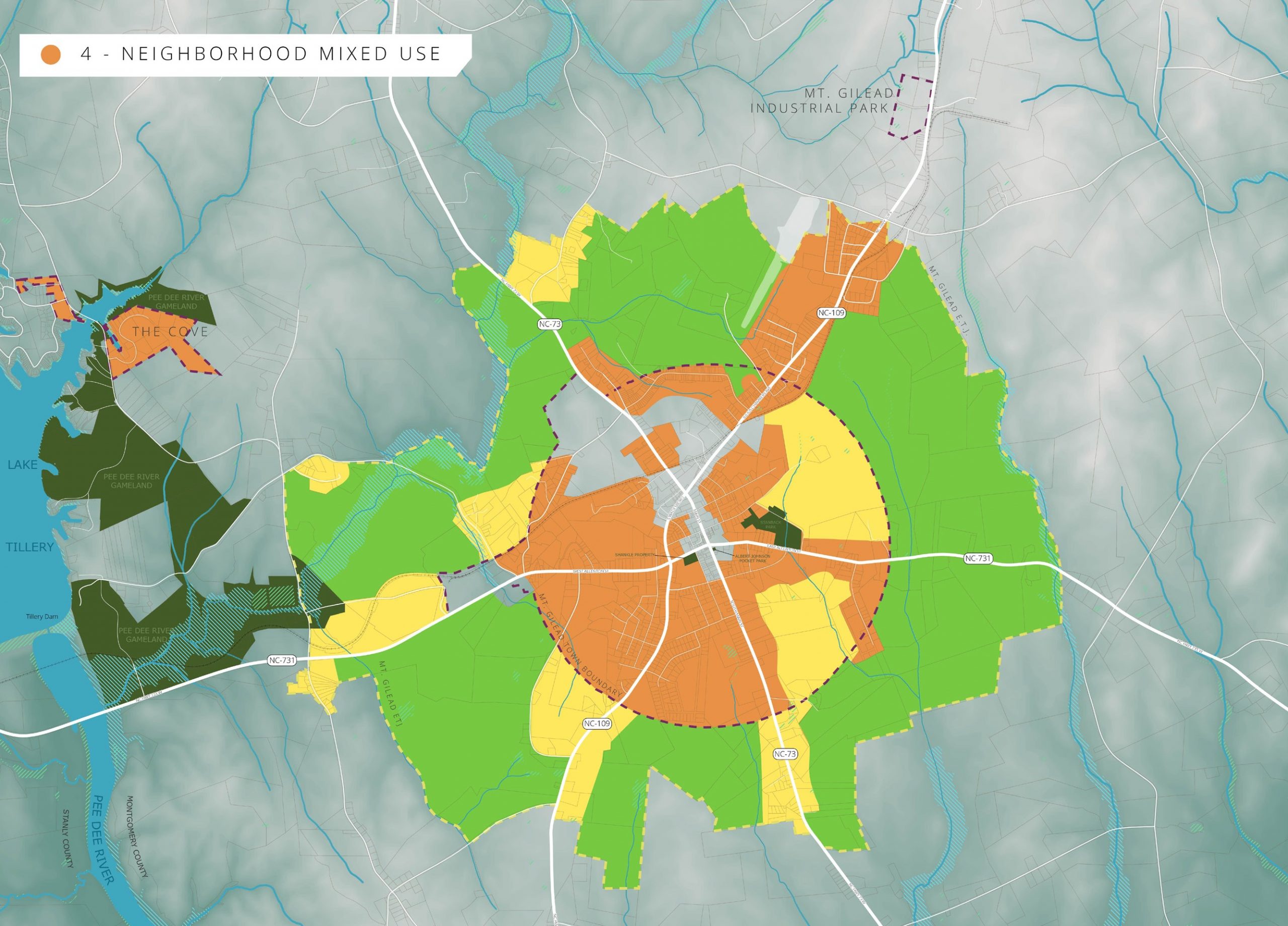
Sector 4: NEIGHBORHOOD MIXED USE
Sector 4 contains medium-density residential developments and neighborhood- scale commercial nodes. This sector is characterized by an interconnected local road network, available water or wastewater, and walkable neighborhoods that connect to parks, preserved open space, commercial nodes, and other neighborhoods. This pattern of development can provide significant public health benefits by creating safe and accessible opportunities for walking and biking.
Appropriate Land Uses and Development Types:
» Medium-density single family neighborhoods
» Mixed residential developments that provide a variety of housing types
» Neighborhood-scale Multi-family developments
» Neighborhood office, commercial, or entertainment mixed-use that could include artisanal maker-space or small-scale manufacturing.
» Civic uses such as parks, schools, fire departments, community centers, libraries, Town and County facilities
» Encourage neighborhood-serving commercial to locate near road intersections, and other neighborhood-serving facilities such as schools and parks and existing compatible commercial uses.
» All new development and redevelopment in Sector 4 shall connect to municipal water service.
» Medium residential densities and compatible commercial uses are encouraged to locate within Sector 4 where both water and wastewater services are available.
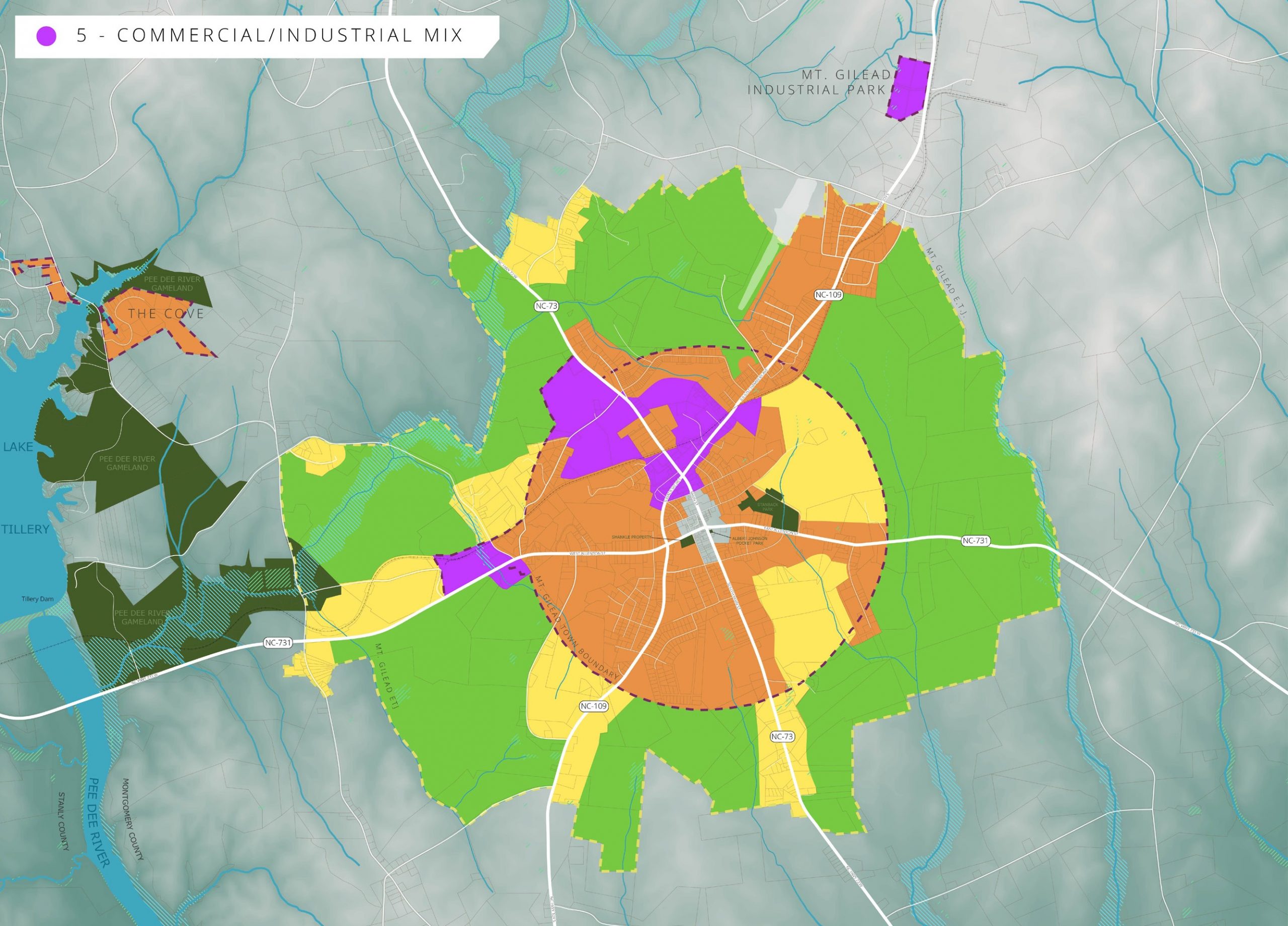
Sector 5: COMMERCIAL/INDUSTRIAL MIX
The Sector 5 classification is supported by major transportation corridors, public water and wastewater infrastructure. This sector provides for a full range of commercial, industrial, and institutional uses that are encouraged to locate within Sector 5 where both water and wastewater services are readily available.
Appropriate Land Uses and Development Types:
» Light Industrial
» Heavy industrial facilities
» Commercial centers with national brands
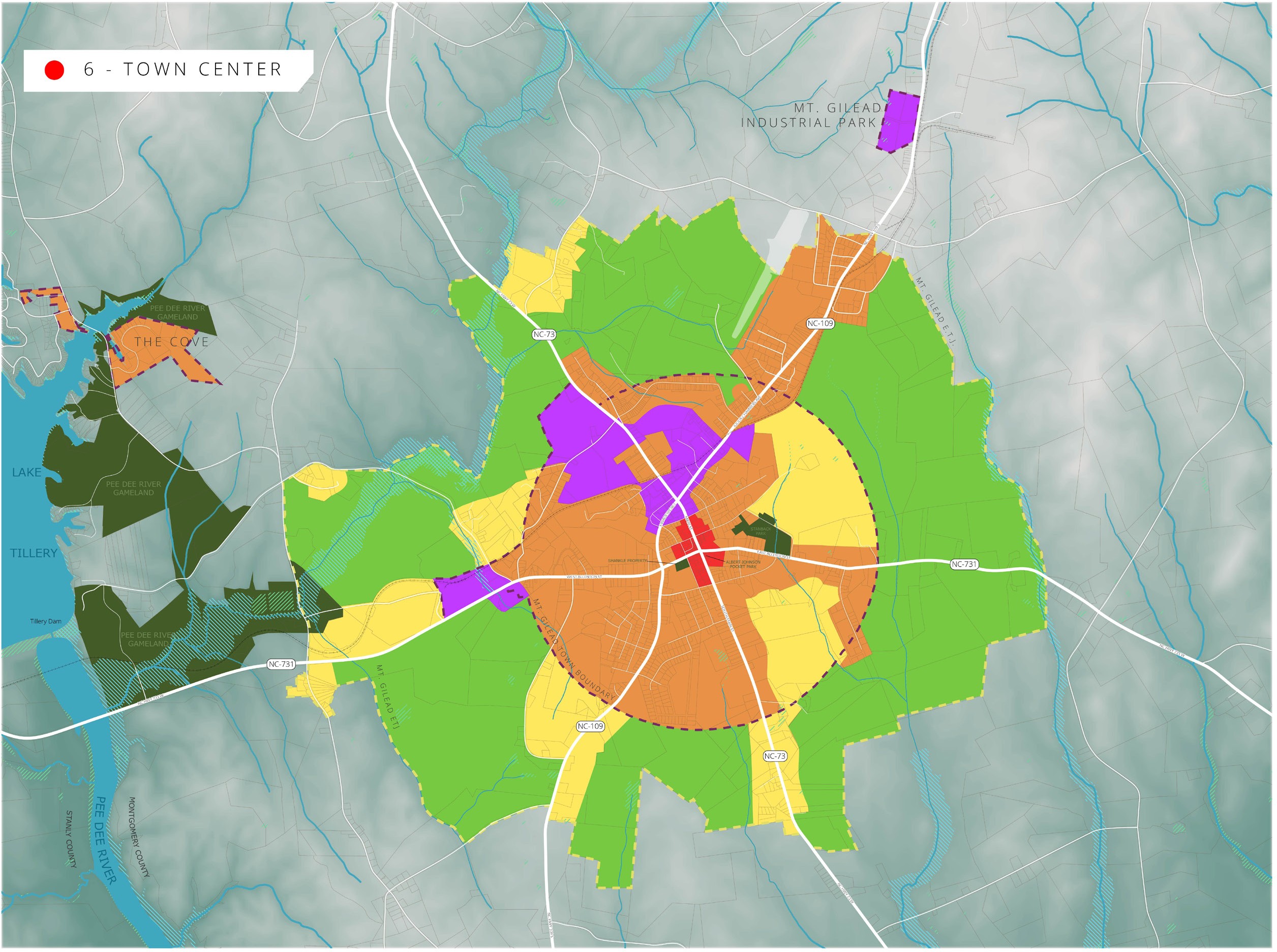
Sector 6: TOWN CENTER
Sector 6 is characterized by a dense, compact street grid, a well-developed pedestrian network, and readily-available water or wastewater infrastructure. The Town Center is a complete community with walkable neighborhoods and pedestrian-oriented streetscapes. Development should prioritize the preservation and rehabilitation of historic buildings, encourage compatible infill development and locate parking on the street or side and rear of buildings. Architectural standards for Mt. Gilead’s Town Center Historic District should be strengthened to ensure appropriate scale, massing, orientation, and location of buildings. The Town Center is well provided for in terms of urban services, making it the most efficient and fiscally responsible area for redevelopment or development of underutilized land.
Appropriate Land Uses and Development Types:
» Mixed residential, commercial, and entertainment uses
» Civic and cultural uses
» Municipal services
» Medium to high residential densities and commercial uses are encouraged to locate within Sector 6 areas where both water and wastewater services are available
MOUNT GILEAD FUTURE LAND USE MAP
LAND USE & ENVIRONMENT POLICY GOALS & RECOMMENDATIONS
1 Encourage new development in areas with existing available infrastructure.
1.1 Amend Zoning Ordinance for consistency with the 2040 Future Land Use Map and recommendations of Mount Gilead Moving Ahead.
1.1.1 Explicitly provide for vertical mixed-use in the Central Business District.
1.1.2 Explicitly provide for neighborhood mixed-used development in Sector 4.
1.1.3 Reduce minimum parking requirements and add maximums for Sector 5, Commercial/Industrial Mix.
1.2 Adopt Conservation Cluster Development standards to encourage smart growth and open space preservation.
1.3 Incentivize new commercial development in targeted growth areas (Sectors 4, 5, 6).
1.3.1 Grant relief from tap fees by spreading payments out over a period of months.
1.3.2 Scale development regulations and requirements based on size of project and impact. Develop a threshold or tier system so as not to over-burden or discourage smaller projects and adaptive reuse.
1.3.3 Reduce or eliminate minimum lot sizes for zoning districts that correspond with Sectors 4, 5, 6.
1.4 Require annexation for all new development around Lake Tillery that desires public sewer service from Mt. Gilead. Require conservation cluster development as conditions of service in order to conserve the natural aesthetic of Lake Tillery and maintain efficient extension of necessary infrastructure.

CASE STUDY #1: A The Financial Case For Smart Growth And Traditional Development Patterns
Property tax revenue is the lifeblood of a local government’s budget. Often, development of any kind is mistakenly heralded as a good thing because it signals new private investment, increased property value, and subsequently, increased tax revenues for the town. But not all development contributes to the long-term wealth
of the town. Towns, cities, and developers have historically measured the productive value of development by the total value of real estate and the total tax production. This metric is inherently flawed in that it ignores the cost of land consumption and long-term public infrastructure maintenance. Growth, in and of itself, does not equate to the creation of wealth. A financially-solvent town needs to make sure that its land use is productive: that the development activity taking place on land within the town is creating enough wealth to support the infrastructure and services needed for that place to continue to exist and thrive. A more accurate measurement of the productivity of development is tax-value per acre. Geoanalytics firm, Urban3, and new urbanism non-profit, Strong Towns, have expertly utilized this method of measurement to prove the efficacy of traditional patterns of development and new smart growth over auto-oriented suburban development at generating long-term wealth rather than long-term maintenance liability for towns and cities. Take for example, the analysis pictured to the left of Lafayette, Louisiana. The 3D model illustrates which parts of the city generate revenue through taxes and which parts cost the city money in maintenance. Green indicates revenue-generating properties (profit), while red signals expense-generating properties (loss). The higher the column, the more revenue or the greater the expense to the city. The analysis clearly indicates that the city’s downtown core, where parcels are smaller and
development is more compact, generates sustainable revenues while the surrounding sprawl costs the city more in services than it generates in revenues.
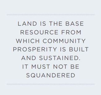
Combining nine small parcels into a 3.5-acre tract at the corner of South Main and Haywood Streets presents an opportunity to extend the traditional mixed-use downtown block to undeveloped land south of the Food King. This concept presents an opportunity for 22,600 SF of new mixed-use space characterized by upper story residential or office space and ground floor retail, entertainment, and restaurants that front on South Main Street. Thoughtful architectural and site design can extend the vernacular of Main Street to create a cohesive aesthetic that respects the historic nature of Mount Gilead’s downtown square. The concept also includes a bungalow or cottage court on School Street that provides single-family workforce housing for young professionals,
like teachers or other public service personnel. The residential component of this concept provides a captive market for ground-floor businesses located in the mixed-use buildings. It provides residents with walkable
access to dining, retail, and recreation in the heart of Town. The suggested policies and code amendments contained in this section of the plan can help facilitate and encourage this type of development. Mount Gilead’s zoning ordinance is one of the most powerful tools that the Town can use to incentivize or discourage certain types of development, so it’s imperative to frequently evaluate the zoning ordinance to ensure that it supports desired development patterns. It’s important to note that this type of development can be constructed in phases over time and does not have to occur all at once. A development concept such as this, in coordination with participating landowners, could be a strong candidate for working with the Incremental Development Alliance, a non-profit aimed at supporting small, local developers who want to implement new neighborhood-scale projects in their own towns. Learn more at incrementaldevelopment.org.
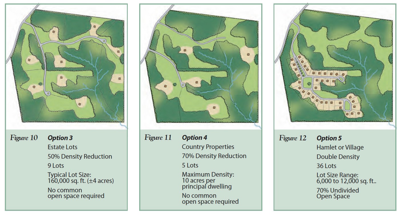
The Conservation Cluster approach to development is characterized by a smaller development footprint that prioritizes green space preservation by designing with a higher number of units per acre clustered in a smaller area of the overall project site. This approach to development is the opposite of traditional suburban sprawl that consumes large acreages for a small number of residential or commercial units. This type of development can be incentivized or even required through the Town’s zoning ordinance. The illustration depicts three approaches to residential development on the same site comparing conventional development with a Conservation Cluster approach. Each development requires the same investment in water and sewer infrastructure, however the Conservation Cluster design quadruples the number of residential units, making the infrastructure investment financially sustainable while also preserving the maximum amount of green space.
- Provide desirable housing that meets the needs of diverse income levels, physical
abilities, and multiple generations.
2.1 Provide a supply of affordable residential lots for development by
ensuring that zoning districts in Sector
4 (Neighborhood Mixed Use) allow for more flexible development standards
such as:
2.1.1 Minimum lot sizes at 5,000 sq. ft.
2.1.2 Minimum lot width at 50ft.
2.1.3 Shallow front and rear setbacks at 15ft.
2.1.4 Zero-lot line or very shallow side setbacks (5ft.)
2.1.5 Encourage garages at the rear or side of houses
2.1.6 Eliminate or reduce the additional lot square footage that is required with the addition of dwelling units.
2.2 Allow duplexes, town homes, condominiums, cottage/bungalow courts, and multifamily housing by-right
in the zoning districts located in Sector 4.
2.3 Attract Low-income House Tax Credit and Senior Housing Tax Credit projects by offering a streamlined zoning process, density bonuses, and reduced minimum parking requirements in Sector 4.
2.4 Explore potential for establishing a community land-trust program that will allow lower income residents to purchase homes and build equity at subsidized rates.
CASE STUDY #2: Creating Community Wealth: Durham Community Land Trust
A community land trust is a legal structure that enables individuals to become homeowners while ensuring the permanent future affordability of homes. In this structure, a non-profit organization (or trust) purchases a portion of land, legally assuming ownership. Individuals purchase or rent homes on this land, while paying a small nominal monthly rental fee for the land on which the house sits.
Homeowners in a land trust build wealth and share this back into the community to ensure future affordability of the homes. As market values of their homes increase, homeowners earn a percentage of this difference at time of resale which also reduces the cost to the next homeowner. This protects the community from gentrification and rising costs of surrounding property. While costs remain low, owners are still able to make improvements to their own homes and maintain their land.
Established in 1987, the Durham Community Land Trust (DCLT) in Durham, NC furthers their mission by making improvements to homes and land for energy sustainability, advocating for transit options in their communities, and expanding property ownership to accommodate rentals and multi-family properties. DCLT has provided rental homes for over 250 adults and 150 youth earning 60% or lower Area Median Income, with average rent $700 lower than the city’s average rent in 2020. By empowering low-income residents and maintaining low housing costs in perpetuity, land trusts protect renters, homeowners, and communities.
CASE STUDY #3: Mobile Makeover: City of Lenoir Mobile Home Standards
Manufactured housing or “mobile homes” provide a form of affordable and practical housing in areas where there is a shortage of reliable housing. When appropriately regulated and located on a site, manufactured homes can exist harmoniously rather than detract from the aesthetics of the surrounding area. The City of Lenoir, NC regulates the placement and exterior features of manufactured homes to preserve the visual integrity of the built environment while allowing this highly affordable and available form of housing as an option for residents who are otherwise unable to purchase or construct their own homes. For example, the City only permits doublewide mobile homes constructed after 1976 and requires the following appearance standards to be met:
» All towing apparatus, wheels, axles, and transporting lights must be removed.
» The home must be permanently placed on a masonry foundation with a finished exterior of brick, stone, stucco, or split-faced concrete masonry units.
» The pitch of the roof must be at least 3 to 12 and finished with a type of shingle that is commonly used in standard residential construction.
» A covered porch must be permanently mounted to the ground at the front door, a minimum of 36 square feet, with a front-gabled roof oriented towards the street.
» Stairs to all exterior doors of the home are required and must be permanently mounted to the ground.
» Exterior facades must be vinyl or wood siding, stone, brick, or other nonmetallic material
CASE STUDY#4: Moving Lenoir to the Second Floor
Many cities seek to renovate historic downtowns with ground-level commercial opportunities and upper story residential units. Promoting the economic and cultural benefits of this kind of redevelopment has empowered property owners, business owners, and more to seek grants and funding to sell and redevelop their property for
second-story residences. Many of the barriers to success for this kind of development are rooted in lack of information and financial support provided to key players and property owners. Lenoir’s “Moving Lenoir to the Second Floor” and Building Upgrades and Improvements for Lenoir Downtown (BUILD) programs help to alleviate these barriers through a variety of financial incentives. In Lenoir’s downtown area, commercial
property owners and business owners renting commercial space are eligible to apply for BUILD grants based on tangible interior and exterior building improvement costs. The BUILD grant has a matching requirement, as recipients are required to invest $2 for every $1 received from the grant, ensuring the program covers 33.33% of all building rehabilitation costs up to $5,000. As a result of these programs’ education and financial incentives, Lenoir has achieved significant progress in downtown redevelopment. As of April 2020, 8 property owners began renovations and 8 more properties sold, ushering in over half a million dollars in private investment in the area
and one-million in private acquisitions in a single year.
- Protect historic quality of downtown Mt. Gilead.
4.1 Continue protecting historic architecture by enforcing both the National
Register Historic District Standards and the Downtown Historic District
Guidelines in their respective districts and requiring Certificates of
Appropriateness for proposed modifications to buildings.
4.2 Consider working with a licensed architect to strengthen the Downtown
Historic District Guidelines by setting specific architectural design
standards and improving clarity with illustrated schematics.
4.3 Amend zoning ordinance to ensure that off-street parking is not required
for businesses in the Central Business District. Explicitly permit shared
parking between adjoining, adjacent, or nearby lots.
4.4 Pursue grant funding from state and federal programs to provide seed
money for a façade grant program to encourage façade upgrades to
downtown buildings.
4.5 Consider establishing a Municipal Service District for the Downtown core
to provide funding for downtown infrastructure, streetscape, and aesthetic
improvements.
4.6 Consider amending code-enforcement regulations to include an Interim
Relief Clause that would allow the Town to make property improvements
at a premium and assess fees or tax-liens on buildings that owners have
failed to upkeep. - Provide appropriate transition between intensity of development.
5.1 Transition Zoning Ordinance toward a form-based code that prioritizes
regulation of the physical form of development (scale, mass, type of
buildings and streets) more than separation of uses.
- Provide for neighborhood-scale commercial nodes.
6.1 Incentivize infill development and redevelopment of existing buildings
through streamlined permit process, reduced application fees, and byright construction.
6.2 Reduce minimum parking standards to allow for easier small-scale
commercial development. Allow on-street parking along the lot frontage
to count toward parking requirement. - Preserve prime timber lands, agricultural lands, open space, and water
resources.
7.1 Partner with Montgomery County to develop a Strategic Land Use
Plan for Lake Tillery aimed at smart growth that conserves the natural
and aesthetic value of the lake and provides for new public access and
recreation locations.
7.2 Work with Montgomery County, Three Rivers Land Trust, and the
NC Wildlife Resources Commission to prevent total privatization and
development of the lakeshore by conserving lakefront property for public
access & low-impact recreation tourism.
7.3 Take an active role in assisting the Yadkin-Pee Dee River Water
Management Group to develop a river basin management plan to balance
pressure on Lake Tillery for increased river flow and drinking-water supply.
7.4 Consider a cap on the number of active Title V air pollutant industries
permitted within the Mount Gilead zoning jurisdiction.
7.5 Encourage owners of prime farmland to take advantage of incentives and
participate in the County’s Voluntary Agriculture District and/or establish
an agricultural conservation easement held by a local land conservancy
like Three Rivers Land Trust.
EXHIBIT #1: Lake Tillery
By the Numbers:
Water Source: Pee Dee River
Created:1 928
Area: 5,000 acres
Miles of Shoreline: 118
Miles from Mt. Gilead: 5
The Tillery hydroelectric dam on the Pee Dee River was put into service in 1928,
creating the 5,000-acre impoundment known today as Lake Tillery. The lake and
hydroelectric dam are managed by Duke Energy. Lake Tillery continues to be
a popular outdoor recreation destination for boating, fishing, and water sports.
Mount Gilead is located less than five miles from the Lilly’s Bridge area on the
eastern side of the lake. This area is home to Lilly’s Bridge Marina, a destination
in its own right as a full-service marina, restaurant, and hang-out complete with
mini-golf. Opposite the lake from Lilly’s Bridge Marina, the North Carolina Wildlife
Resources Commission manages a public boat launch and lake access area with
vault toilets and a large, modern picnic shelter. The Pee Dee River Blueway, a
designated section of the Carolina Thread Trail, begins south of the Tillery
Hydroelectric Dam and extends 30.5 miles to Rockingham.
Over the past decade, the shoreline of Lake Tillery has seen increasing development
of private residential subdivisions, including The Cove, a satellite annexation
of Mount Gilead. While Mount Gilead does not have jurisdictional control over
property surrounding Lake Tillery, it can leverage regulatory authority over new
developments through its utility extension policy and annexation policy. It is in
the Town’s best interest to work with Montgomery County and local land trusts
to develop a conservation plan for Lake Tillery to ensure the preservation of this
asset for outdoor recreation tourism and public lake access.
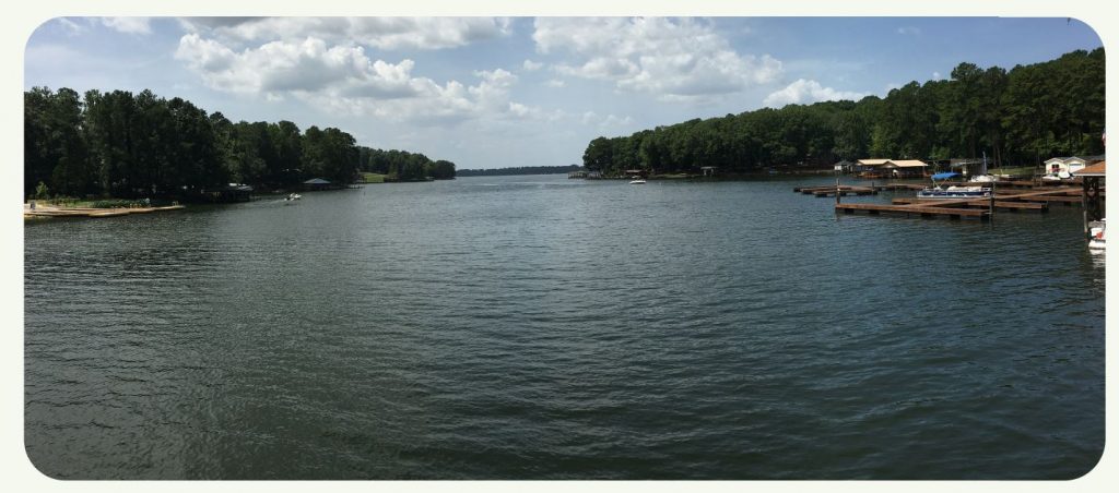
ECONOMIC PROSPERITY
Manufacturing is a proud tradition in Mount Gilead and currently employs
over one-third of the population. The manufacturing companies appear
to be stable long-term employers given that many are engaged in the
production or processing of wood and paper products from the area’s abundant
timber and have easy access to the state highways that criss-cross the town. Mount
Gilead’s industrial park faces challenges, but provides a readily-available location for
new industrial tenants and should be marketed widely to diverse sectors including
emerging technology, logistics & distribution, and green industries, in addition to
traditional manufacturing.
Mount Gilead’s greatest opportunity for diversifying its economy lies in the town’s
ability to capitalize on its proximity to Lake Tillery, the Uwharrie National Forest, Pee
Dee River, and Town Creek Indian Mounds as outdoor recreation tourism destinations.
Mount Gilead’s well-preserved, historic downtown has the potential to establish the
town as a basecamp for the outdoors by offering unique shops, restaurants, and
even lodging in a friendly, walkable atmosphere. In a shifting economy where remoteworkers can live anywhere, the town is poised to leverage these assets to attract a
new wave of residents and investment. It’s imperative that Mount Gilead’s economic
development strategy include a diverse range of initiatives
POLICY GOALS & RECOMMENDATIONS
- Attract new citizens and visitors to Mount Gilead.
1.1 Implement a distinct & recognizable visual brand for the Town.
1.2 Build upon the 2020 Montgomery County Marketing & Tourism
Assessment to develop a Mount Gilead-specific marketing strategy:
1.2.1 Identify the Town’s target audiences for downtown visitation and
outdoor recreation tourism
1.2.2 Identify a strategy for traditional and digital marketing, including
social media outreach
1.3 Promote downtown Mount Gilead to new residential developments around
Lake Tillery.
1.4 Redevelop the Town website based on target market research and key
messaging about Mount Gilead’s downtown & outdoor recreation assets.
1.5 Partner with downtown churches and civic uses, such as the elementary
school, to provide additional public parking during times that the parking
lots are not used for church or school. Install signage to direct visitors to
these lots. - Leverage natural resources for outdoor recreation and agritourism.
2.1 Work with the Piedmont Triad Regional Council (PTRC) to establish Town
participation in the Outdoor Recreation Advisory Council.
2.2 Install wayfinding signage from nearby recreation destinations to
Downtown Mt. Gilead.
2.2.1 Town Creek Indian Mound State Historic Site
2.2.2 Lake Tillery & Lily’s Bridge Marina
2.2.3 Uwharrie National Forest
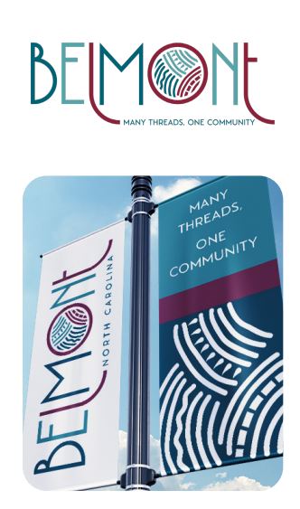
CASE STUDY #5: Placebranding: Community-Driven Visioning in Belmont, NC
Place-branding is a community-driven visioning process aimed at achieving consensus on identity and aspirations. A place-brand reflects the character and spirit of the community. In essence, it is a storytelling tool; a vehicle for broadcasting a community’s identity. Place-branding communicates both tangible and intangible assets of the City through visual and written mediums. The place-branding process answers vital questions about the community’s identity and shared goals. Results of the place-branding process have significant implications for community and economic development.
Throughout 2019 and 2020, the City of Belmont, NC engaged in a place-branding process to discover, organize, and articulate the city’s identity by developing a brand identity, tagline, and logo system. The process included in-depth stakeholder and pubic engagement through focus groups and an online survey to inform development of the brand identity and style. The resulting brand platform, logo system, and promotional collateral represent the celebrated diversity of Belmont and its many offerings while honoring the City’s heritage as a railroad town and former textile hub. The place-branding campaign included the creation of brand collateral such as downtown banners, storygraphics for marketing, a signage package for new city facilities, and a promotional video.
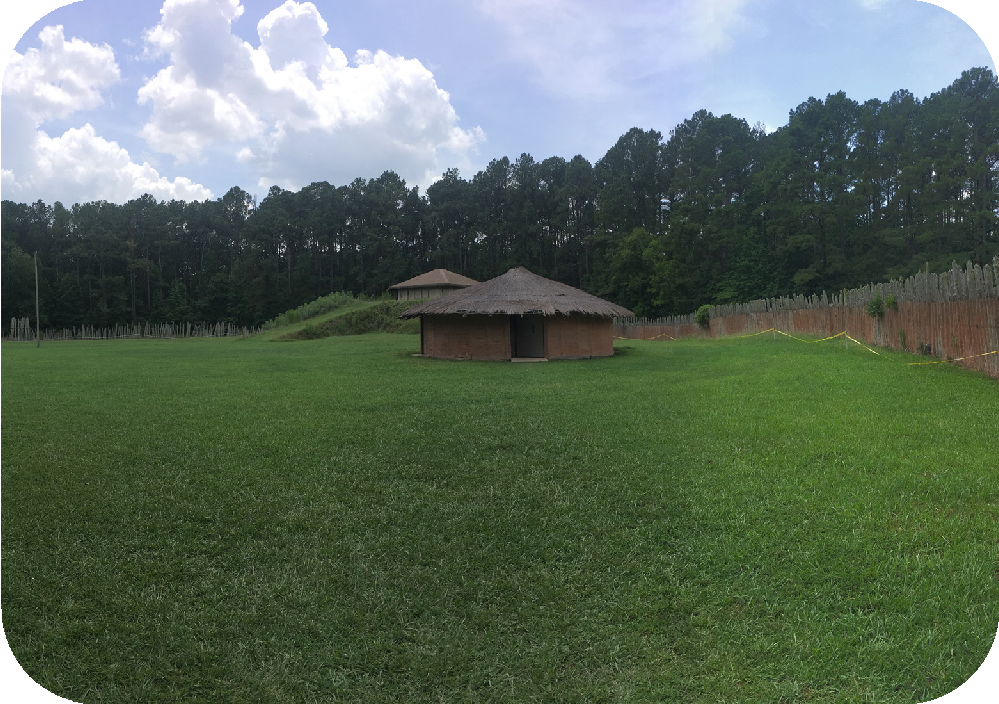
EXHIBIT #2: Town Creek Indian Mound State Historic Site
BY THE NUMBERS:
Settlement Established: 11th Century
State Historic Site Established: 1955
Annual Visitors: 20,000
Miles from Mt. Gilead: 3.5
Town Creek Indian Mound State Historic Site, located 3.5 miles southeast of Mount Gilead at the confluence of Town Creek and the Little River, is one of the most archaeologically significant sites in North Carolina and has been the subject of continuous archaeological investigations since 1937.
Town Creek Indian Mound, the only state historic site dedicated to interpreting Indigenous heritage, preserves 11th century Pee Dee indigenous culture through re-constructed mounds and structures. The state historic site includes an interpretive center on site and attracts more than 20,000 visitors per year.
From around 1200-1400, the Pee Dee culture flourished in trade and craft. The various mounds and fortified structures served multiple community purposes, from mortuaries and burial sites to ceremonial spiritual and political venues. Mount Gilead honors these original inhabitants with a large mural facing Allenton Street in downtown.
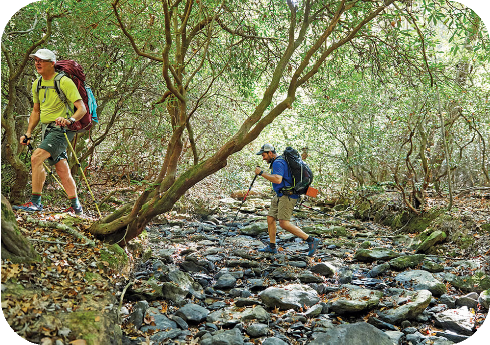
Photo by: Adam Mowery for Our State Magazine
EXHIBIT #3: Uwharrie National Forest
BY THE NUMBERS
Established:1961
Land Area: 52,000 acres
Miles of Hiking Trails: ~85
Miles of Mtn. Bike Trails: 60
Miles of Equestrian Trails: 40
Miles of OHV Trails: 17
Miles from Mt. Gilead: 8
A defining feature of the region, the Uwharrie National Forest was established in 1961, making it one of the newest additions to the National Forest system. The 52,000-acre wilderness rises from the Yadkin & Pee Dee Rivers to provide the region with an enormous source for outdoor recreation adventures. The National Forest offers hiking, mountain biking, Off Road Vehicle, and equestrian trails in addition to camping, fishing, hunting, and a shooting range. Approximately 25 miles of the planned 50-mile Uwharrie National Recreation Trail are established in the National Forest today. As demand for outdoor recreation amenities continue to grow, Mount Gilead has a significant opportunity to leverage its proximity to the Uwharrie National Forest through strategic marketing efforts and the establishment of a physical connection from town to trails via a multi-use path.
2.3 Re-establish a community farmers market in downtown Mount Gilead.
2.4 Encourage farm-to-table restaurants.
2.5 Encourage farm stands and markets with value-added agricultural
products.
2.6 Encourage grocers and food-service businesses to source local products
for sale and distribution.
2.7 Encourage and promote area agritourism enterprises such as you-pick
farms, vineyards/wineries, breweries, farm tours, mazes, and nature-based
destinations.
2.8 Partner with Montgomery Community College, Piedmont Conservation
Council, Three Rivers Land Trust, Center for Environmental Farming
Systems, Montgomery County Soil & Water Conservation District,
and local agricultural landowners to establish an incubator farm that
provides available land and capital to aspiring farmers and agricultural
entrepreneurs

CASE STUDY #6: Growing the Next Generation of Farmers: Hines-Chapel Incubator Farm
Mt Gilead and surrounding Montgomery County have a rich agricultural history, but with a nationwide shortage of new farmers due to lack of funding, land, and other resources, it is essential to take active steps to preserve this agricultural heritage. One way to encourage new and sustained agricultural activity is through the support of an incubator farm. Incubator farms are like incubator businesses as they assist start-up farms and agricultural businesses in the form of access to land and capital. The goal of incubator farms in general is to lower the barrier to entry for family or small farms to thrive and prosper in the early years of establishing.
The Hines Chapel Incubator Farm proposed in Guilford County provides tangible resources to help ensure success of small, new farms through shared infrastructure, equipment, storage facilities, access to rentable tracts of land, market access, and professional training. Its management structure is in the form of a non-profit organization, which encourages the organization to operate in interest of the public good and not face larger financial hurdles while ensuring a consistent and dedicated staff. This Hines Chapel Incubator Farm also has been developed through intensive public engagement with key stakeholders through workshops and meetings, leading them to be able to form specific mission statements, goals and objectives for their individual project area. A clear strategic plan for incubator farms considering the local area’s needs, funding, land access, management structures, and partnerships with community resources can bolster the success of the new and growing farmers.

- Attract new businesses while supporting the retention and expansion of
existing businesses and industry.
3.1 Request assistance from the NC Main Street Rural Planning Program to
develop a Five-year Strategic Plan for the Mount Gilead Redevelopment
Corporation. Include strategies for expanding operations to include
broader economic development tasks such as marketing, business
recruitment, small business support, and property acquisition for
redevelopment.
3.2 Attract new, clean industry to Mount Gilead.
3.2.1 Work with Montgomery County and Jordan Lumber to pursue
Certification for the Industrial Park through Duke Energy’s Site
Readiness Program.
3.2.2 Continue working with PSNC, Montgomery County, and Jordan
Lumber to resolve natural gas volume issues at the Industrial Park.
3.2.3 Work with Jordan Lumber and Montgomery County to brand
and promote the Industrial Park to appeal to a variety of modern
industries including tech uses such as data centers or server farms.
3.2.4 Amend zoning ordinance to allow for solar farms in Sectors 2 &
3 with appropriate regulatory and design standards to protect
significant viewsheds and rural vistas.
EXHIBIT #4: Duke Energy Site Readiness
The Mount Gilead Industrial Park is a Certified North Carolina Industrial Site, meaning that this site has been vetted for certain characteristics and has completed specific site preparations in order to demonstrate a greater level of preparedness for new industrial operations. The industrial park could further distinguish itself and benefit from greater visibility by participating in Duke Energy’s Site Readiness program. The program allows local government and economic development officials to work with professional site selection consultants to determine a strategy for further enhancing a site with the goal of recruiting national companies to North Carolina. Additionally, participating sites are eligible to apply for a $10,000 matching grant from Duke Energy to implement the strategy. After each site’s state of readiness has advanced, Duke Energy’s business recruitment team markets each site nationwide to targeted companies looking to expand or relocate their operations. The program is highly competitive, with only six sites selected for participation in 2020, but it has proven successful. Since its inception in 2005, the program has helped prepare properties across the state resulting in 5,650 new jobs and nearly $6.4 billion in capital investment. Duke Energy is the electric provider for sites participating in the program.
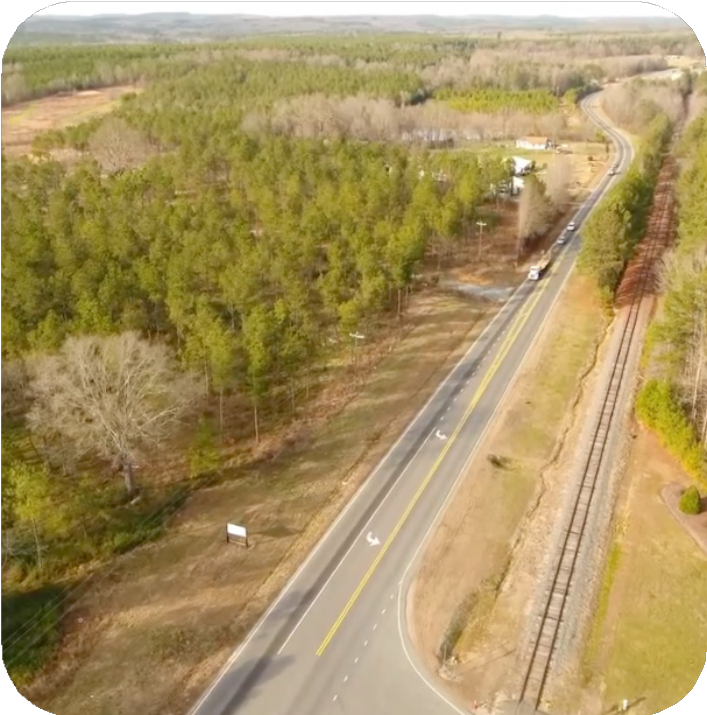
3.3 Attract businesses that supply basic goods and groceries to Mt. Gilead.
3.3.1 Work with property owners with available land in targeted growth
areas (Sectors 4, 5, 6) to develop a strategy for commercial
recruitment.
3.4 Encourage and grow small and mid-sized businesses.
3.4.1 Continue active participation in the NC Small Town Main Street
Program. Leverage grant opportunities available to member Towns
for business recruitment and building renovations.
3.4.2 Establish a dedicated business incubator space in the Piedmont
Arts Center that fosters innovative start-ups, young businesses,
artisans, and minority-owned businesses. Consider renaming this
building to appeal to a broader range of entrepreneurs.
3.4.3 Work with Market Montgomery Chamber of Commerce & Tourism
to develop and implement targeted social media campaigns that
highlight Mount Gilead businesses.
3.4.4 Develop strategic partnerships with Piedmont Triad Regional
Council Business Investment Fund and other non-profit Community
Development Financial Institutions to facilitate financial assistance
for start-ups and small businesses located in the greater Piedmont
Triad region that are underserved by traditional financial institutions.
CASE STUDY #7: Textile Mill To Opportunity Factory: Gaston Techworks
Business incubators are designed to foster local innovation and collaboration, house budding small businesses, and offer educational opportunities all under one roof. Entrepreneurial individuals from the community have access to shared office space at lower costs than a traditional office, and benefit from a variety of resources offered by the organization.
One successful example is TechWorks, a technology-focused nonprofit business incubator in Gaston County. Branded as an entrepreneurial tech hub and learning center “committed to job creation, economic growth, innovation, and talent development,” TechWorks centers their mission on empowering the local community. Partnering with OpenBroadband, they have provided free Wi-Fi to the surrounding area and downtown, as well as other businesses and residents in the county. They have also partnered with Gaston College, UNC Charlotte, and other K-12 school systems to provide training in subjects such as coding, digital marketing, and entrepreneurship. By offering essential services that will grow into the future, TechWorks has succeeded in acquiring 2.5 million dollars of funding in government investment along with private and foundation contributions. TechWorks inhabits a renovated former textile mill, which offers 14,000 square feet of co-working space, conference rooms, and event space. The renovation of industrial buildings into hubs of economic and community growth also offers a great opportunity for transforming aging infrastructure into a multi-functional working venue for small local businesses by leveraging historic mill preservation tax credits.
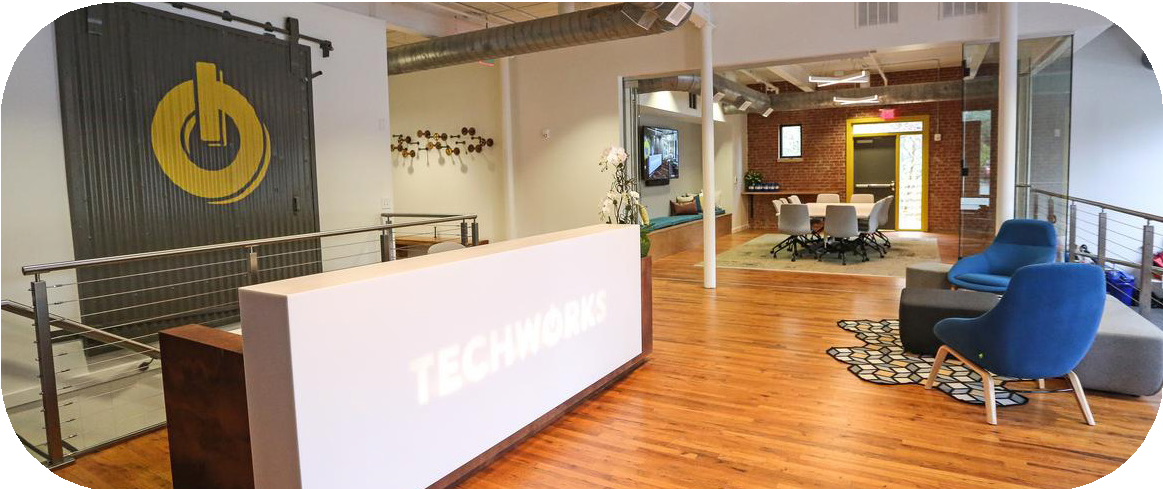
- Attract businesses that supply basic goods and groceries to Mt. Gilead.
- Work with property owners with available land in targeted growth areas (Sectors 4, 5, 6) to develop a strategy for commercial recruitment.
- Encourage and grow small and mid-sized businesses.
- Continue active participation in the NC Small Town Main Street Program. Leverage grant opportunities available to member Towns for business recruitment and building renovations.
- Establish a dedicated business incubator space in the Piedmont Arts Center that fosters innovative start-ups, young businesses, artisans, and minority-owned businesses. Consider renaming this building to appeal to a broader range of entrepreneurs.
- Work with Market Montgomery Chamber of Commerce & Tourism to develop and implement targeted social media campaigns that highlight Mount Gilead businesses.
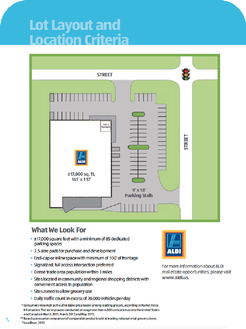
EXHIBIT #5: ALDI Real Estate Opportunities
One of the primary issues raised by citizens throughout the public engagement phase, was the lack of businesses that supply basic goods and groceries. While Mount Gilead does have a small grocery store, many residents leave the town, and even the county, to do their weekly shopping. This results in retail leakage for the town as dollars earned by citizens are spent elsewhere, and is perceived as a quality of life issue for current and future residents. In evaluating strategies to address this challenge, both the Town and owners of available property should be discerning in their decision making to ensure that new development in complementary to the town’s existing character in scale and corporate responsibility. One option to consider is the modestly-sized grocery chain, ALDI. ALDI operates with an aggressive expansion model and has an active real estate program that is continuously seeking new available locations. The company lists specific site criteria on the real estate opportunities section of its website, and invites property owners or project partners to submit candidate properties for consideration directly to the regional real estate contact.

EXHIBIT #6: Community Development Financial Institutions
In addition to the PTRC Business Investment Fund, the Greensboro Community Development Fund, Carolina Community Development Fund, and Piedmont Business Capital are all North Carolina Community Development Financial Institutions (CDFIs) that lend to start-ups and expanding local businesses, with an emphasis on supporting businesses that have difficulty accessing financing through traditional lending sources.
These non-profit community loan funds support underserved communities and community- minded entrepreneurs that are committed to starting and building locally-owned small businesses. CDFIs focus on lending to socially responsible businesses and organizations that stand to make an impact in revitalizing their communities. Each CDFI offers flexible rates, personal business counseling, and an higher rates of loan approval for non-traditional businesses and minority-owned businesses.
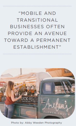
3.4.5 Attract vibrant transitional businesses, such as food trucks and popup vendors, by amending the Zoning Ordinance to permit these
uses by right in appropriate locations.
3.4.6 Partner with available commercial property owners to recruit
successful businesses in nearby towns to open second locations in
Mount. Gilead by offering subsidized rent and/or utilities during the
start-up period.
3.4.7 Amend Zoning Ordinance to allow and encourage outdoor patio
seating and dining on downtown sidewalks with adequate width.
3.4.8 Scale zoning and development permit fees by project size so that
fees are proportionate to the size and cost of the project.
3.4.9 Reduce restrictions on home-based businesses to foster
fledgling small business, expand the local economy, and increase
neighborhood wealth.
3.4.10 Partner with property owners of vacant commercial lots in
downtown to attract and incentivize infill development that extend
or fill gaps in the street wall.
3.5 Attract new lodging business to support the tourism industry.
3.5.1 Work with downtown property owners with available buildings to
attract a boutique hotel.
3.5.2 Amend Zoning Ordinance, consistent with state regulations, to allow
for Airbnbs that will provide lodging for visitors and an extra source
of income for Mount Gilead residents.
3.5.3 Pursue a Public-Private Partnership with a project-specific
development agreement to develop a unique Town-owned lodging
destination oriented toward outdoor recreation travelers. In this
arrangement, a private company can lease the property from the
Town and conduct business operations of the facility
CASE STUDY #8: Treehouse Tourism on the Cashie River
In 2016, the Mayor of the small Town of Windsor formed a committee to find new ways to boost tourism utilizing the 55-mile Cashie River which flows through the town. The committee leveraged their natural resources to develop a unique tourism destination in a set of small, tucked away elevated cabins which sit above the river in the trees. These treehouses are linked to the nearby campground and the natural landscape with a 480-foot-long boardwalk to intertwine the experience of tourists with the natural setting. With a $190,000 grant from the NC Department of Commerce, Windsor contracted experts from the reality TV show “The Treehouse Guys” to help design and build the treehouses and used this filmed opportunity to further amplify the marketing for their area. Tourists are encouraged to engage with the town’s natural setting with nearby kayak and canoe rental and guided river tours. Local Food Trucks also offer food to visitors in the campground or tourists travel to the nearby downtown area to dine. Since opening in 2017, the treehouses have seen near-constant rental by visitors to Windsor from across the country. Building off this success, the town later received another large state grant to add two more treehouses which were opened late 2018.
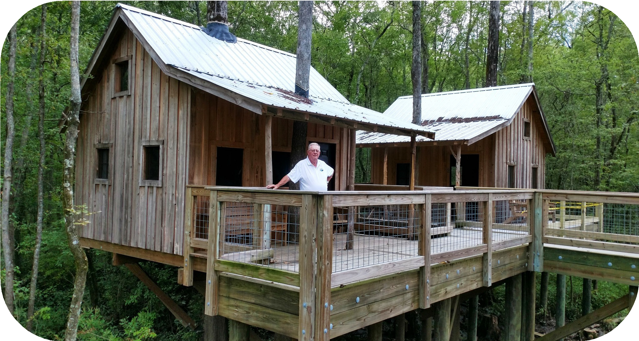
CASE STUDY #9: From Vacant to Vibrant: Adaptive Reuse through Public-Private Partnerships
Public-Private Partnership (P3) legislation, passed by the NC General Assembly in 2013, provides flexible contracting authority under which local governments can partner with a private developer for the construction, operation, and financing of a capital project. The Town of Hendersonville recently utilized this contracting authority to rehabilitate and convert a dilapidated historic mill building to create 35 new rental apartments for workforce and moderate-income residents. The freshly renovated Grey Mill in downtown Hendersonville opened its doors to new residents in 2020, offering a positive impact on the local economy and quality of life of the area workforce.
With a total development investment of $8.5 million, the town of Hendersonville was able to partner with multiple private and public entities to redevelop the Grey Hosiery Mill which stood unused and vacant for over 20 years. One close partnership was with the Development Finance Initiative (DFI) at the UNC School of Government. DFI offered a variety of services including parcel analysis, public engagement, and creating a comprehensive redevelopment plan for the project. DFI also helped to select Belmont Sayre, LLC as a private developer to partner with Hendersonville for the renovation of Grey Mill.
The success of the project has led to the city and developers being honored with multiple awards including the NC Main Street Award the Bronze Rank in the Real Estate Redevelopment and Reuse category of the International Economic Development Council’s awards program. The property value is now estimated at
$6 million and is expected to generate nearly 65 thousand dollars of tax revenue for the city and county each year. The location of the mill along with the massive amount of local and statewide support and funding also catalyzed even more overall development throughout the area.
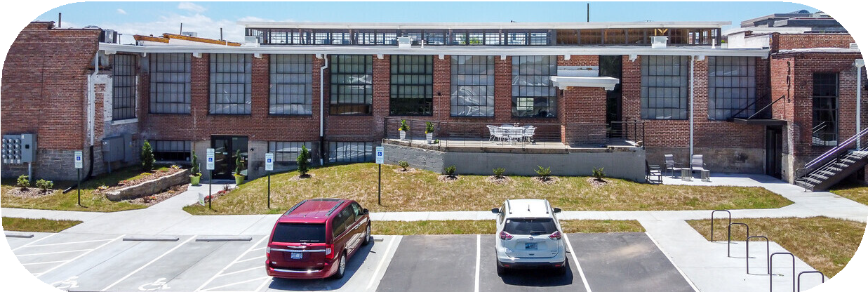
3.6 Publish and promote an inventory of
available industrial properties in
Sector 5.
3.7 Continue working with PTRC to
identify candidate sites for the
Regional Brownfields Redevelopment
Program.
3.8 Preserve and facilitate adaptive re-use
of Mount Gilead’s historic structures.
3.8.1 Coordinate with private owners
and potential re-developers of
historic properties to pursue
state and federal historic
preservation tax credits to
complete adaptive reuse
projects of historic mills and
factories.
3.8.2 Follow recommendations
of the 2018 Construction
Professionals Network Institute
& NC Growth – Mt. Gilead
Report for assessing, acquiring,
and rehabilitating the RussellHarvell Hosiery Mill. Consider a
Public-Private Partnership with
a project-specific development
agreement to rehabilitate the
site and return the mill to a
productive mixed-use facility.
(See Appendix C for details
on Public Private Partnership
legislation).
3.8.3 Work with a consulting firm to
assess the community’s desired
use for the Historic Train Depot
and evaluate the integrity of
the structure and feasibility
of rehabilitation for adaptive
re-use
3.9 Return abandoned commercial
properties to productive use and
encourage new infill development by
developing a strategic foreclosure
program for properties that are
severely tax-delinquent and are
routinely cited for code violations.
CASE STUDY #10: Delinquent to Desirable: Returning Properties to Productive Use through Strategic
Foreclosures
A Strategic Foreclosure is a tool available to most towns and cities to recover tax dollars while putting abandoned properties back on the private market for redevelopment. Often, towns must invest tax dollars to abate abandoned properties through the code enforcement process. If a property owner fails to pay the town for the cleanup, those charges are added as a lien on the property, just like unpaid taxes.
By foreclosing on such properties, Mount Gilead can create investment opportunities in a neighborhood while avoiding growing costs associated with never-ending abatement efforts. And when properties are proudly owned and maintained, neighborhoods are stronger and more resilient.
When a tax delinquent property faces foreclosure, any party that has an ownership interest must be served notice of the foreclosure action. Parties with ownership interest have an opportunity to pay the past due taxes to avoid foreclosure. The City of Lenoir works closely with a law firm that specializes in these types of foreclosures because most abandoned properties identified for strategic foreclosure require extensive title work to identify the owners. Often, a Guardian Ad Litem is appointed on behalf of unknown heirs. On average, it takes 12-18 months from the time the City of Lenoir initiates foreclosure until the time the property is auctioned.
Employing this process, the City of Lenoir has successfully returned several dilapidated and/or delinquent properties to active use at the hands of private investors. Occasionally, the City becomes the owner of the property and can market and sell the property itself or pursue strategic development projects through a Public-Private Partnership.
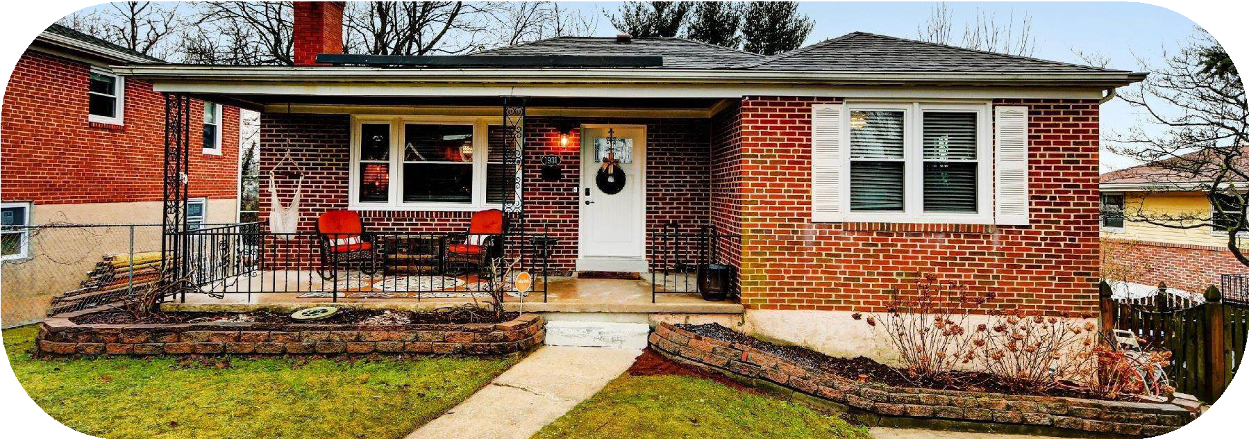
CASE STUDY #11: Getting connected: Grants Expand Internet Access in Rural NC Towns
In 2016, ten rural NC towns received $272,000 in grant funding from the Appalachian Regional Commission to expand broadband internet in their towns. A total of 415 businesses were impacted by the internet expansion. In the Town of Walnut Cove, free downtown WIFI was installed that now allows every business on Main Street to utilize the free internet rather than paying for it individually. Programs and grants similar to the ARC grant are made available through the NC GREAT grant program and MCNC. The GREAT (Growing Rural Economies with Access to Technology) program was authorized by the NC General Assembly in 2018 and subsidizes the costs of private companies providing connectivity in rural areas where the limited number of households make it unprofitable to extend broadband service. MCNC is a non-profit fiber-optic provider that maintains an open-source fiber-optic backbone across the state. MCNC also provides middle-mile fiber optic service to anchor institutions such as community colleges or local governments. The network is also available for private telephone, electric, or internet providers, to connect and then provide last-mile service to residences and businesses.

- Increase socioeconomic mobility by
expanding accessibility to broadband
internet.
4.1 Work with local internet service
providers to pursue grant funding
to expand internet access in Mount
Gilead.
4.2 Explore potential to use the Spectrum
Internet Assist program: a low cost
broadband program delivering up to
30 MBPS to low-income households.
4.3 Work with Montgomery County
Schools to continue operation of WiFi
hotspots in Mount Gilead.
4.4 Support the continued operation
of Highland Community Center’s
internet classrooms.
EXHIBIT #7: Highland Community Center & Montgomery Community College Partner to Bridge the Digital Divide
Even before the COVID-19 pandemic exposed the depth of the digital divide in America,
Highland Community Center was exploring ways to bridge the local gap and provide free
internet to approximately 42% of Mount Gilead residents who do not have access to internet at
home. When local schools transitioned to onlineonly instruction, the urgency for establishing internet classrooms increased. In partnership with Montgomery Community College and supported by CARES Act funding, Highland opened four internet classrooms to students in the fall of 2020. The classrooms were complete with COVID-19
PPE and staffed by a full-time coordinator. This significant effort complemented other community-led efforts to provide internet access including a free WIFI hotspot provide by McRae Industries in their corporate parking lot and free WIFI provided by the Town outside of Town Hall, the Police Department, and Fire Station.

CASE STUDY #12: Yeehaw! The Durham Central Park Food Truck Rodeo
Hosting a food truck rodeo is a unique way to bring new visitors to downtown while showcasing local and regional street food and budding culinary businesses. In Durham, the Central Park Food Truck Rodeo operates rain or shine on five Sundays throughout the year through the afternoon from 12-4pm. Residents and tourists gather in central park and can pick and choose drinks, meals, and snacks from a bouquet of local food trucks that line up along 2 sections of closed streets. The options range from small vendors of popcorn or popsicles to full meals from restaurants-turned trucks. Located in an area where Durham’s farmer’s market is located, most visitors are familiar with the venue and can lounge, play and dine in the shaded grassy areas or surrounding picnic tables. A small play area and pavilion area also offer further engagement. The event brings visitors of all ages and interests to the area directly adjacent to Durham’s downtown area with an abundance of free parking options in dedicated weekend lots. This food truck rodeo guides individuals to a high-energy, explorative event that continues as people venture into retail and restaurant venues less than a 5-minute walk down the street.

- Continue to invest in and promote seasonal festivals and events to tourists and regional visitors.
5.1 Continue investing in and growing
Mount Gilead’s existing festivals.
5.2 Consider hosting new non-traditional
festivals and recurring monthly events
downtown.
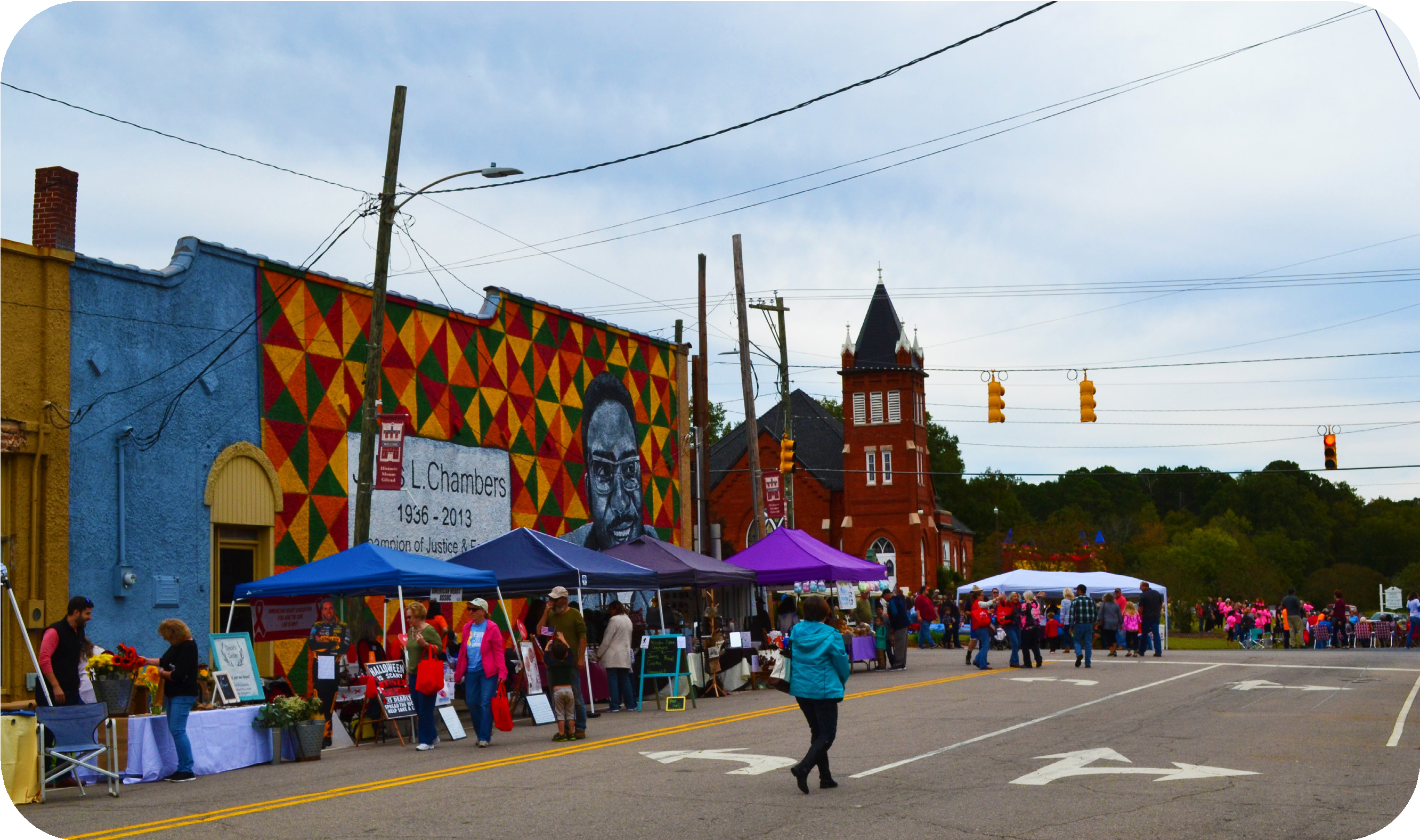 Mount Gilead Annual Fall Festival

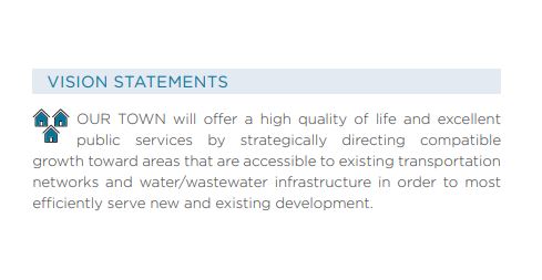
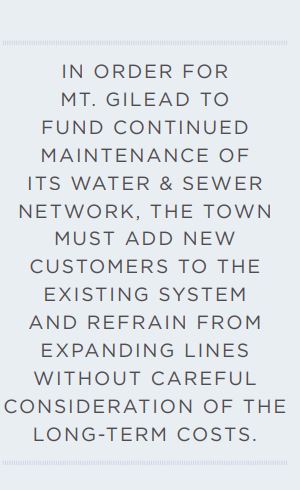
Mount Gilead provides critical infrastructure and support services to ensure
public safety and welfare. These critical services and infrastructure
include: wastewater treatment, a public water system, public works, and
law enforcement. The Town works closely with the Mount Gilead Volunteer Fire
Department to ensure fire protection for the Town’s citizens and structures. Curbside
garbage collection is contracted out to a large sanitation service provider. Citizens
can participate in a self-service recycling program by depositing their recyclables at
a central location at Town Hall. Curbside recycling and leaf/limb pick up are currently
not provided as regular services.
Mount Gilead’s aging water and sewer infrastructure requires substantial upgrades.
The Town has made continuous progress on necessary improvements over the past
decade with the help of grant programs, but efforts must remain ongoing to replace
lines and infrastructure in order to avoid system failures.
Maintaining the public water and wastewater systems is one of the Town’s most crucial
services. Mount Gilead’s growth management policies have a significant impact on
the Town’s ability to continue providing quality water and wastewater services to
all customers. Currently, the Town evaluates applications for public water and sewer
service according to the Utility Allocation and Extension Policy, first adopted in 2007.
The Town’s utility allocation policy and continued ability to provide safe and efficient
water & wastewater service is inextricably linked to its development policies and
regulations.
In order for Mount Gilead to fund continued maintenance of its water and sewer
network, the town must add new customers and development to the existing system
and refrain from expanding water and sewer lines without very careful consideration
of the long-term maintenance costs.
POLICY GOALS & RECOMMENDATIONS
- Continue to provide safe, high-quality public water and
wastewater service in a sustainable and fiscally responsible
manner.
1.1 Continue implementation of the Town’s 20-Year Capital
Improvement Plan for water and sewer infrastructure to plan
for replacement of aging water and sewer infrastructure,
prioritizing targeted growth areas (Sectors 4, 5, 6).
1.2 Update inventory of water and sewer lines and facilities to
systematically prioritize upgrades.
1.3 Pursue state grants and USDA loan funding to facilitate
replacement of aging water and sewer infrastructure.
1.4 Coordinate with Montgomery County Planning to
manage residential growth around Lake Tillery to ensure
that development doesn’t outpace water and sewer
infrastructure.
1.5 Review the 2007 Utility Allocation and Extension Policy to
require that new development must connect to the Town’s
water system at the expense of the developer if it is within a
reasonable distance from an existing water main. Continue
extension policies that ensure that the cost of growth is not
borne by existing water customers.
1.6 Any Town-initiated expansion of utilities shall reinforce
targeted growth sectors (4, 5, & 6) for increased
development densities.
1.7 Develop standard details for construction of water and
wastewater infrastructure to ensure quality, consistency, and
adequate volume and pressure for fire suppression. - Correct service gaps in solid waste collection for yard waste and
recycling.
2.1 Determine demand for curbside recycling & yard waste and
the price threshold that customers are willing to pay for
these services. If demand warrants, contract with service
provider for curbside recycling and yard waste collection.
2.2 Encourage waste reduction strategies by promoting and
providing education on composting, mulching, reuse,
recycling, and reducing litter.
- Attract and retain qualified, high quality personnel in all Town
departments.
3.1 Conduct study of peer cities & towns to identify
improvements that can be made to employee benefits
packages.
3.2 Conduct a rate study for employee salaries and wages.
3.3 Develop a take-home vehicle program for police officers as
an incentive for new hires. - Continue to support the Mount Gilead Volunteer Fire Department
in providing excellent fire and emergency response services.
4.1 Attract and retain qualified, high quality fire volunteers and
personnel.
4.1.1 Work with Montgomery County to evaluate and plan
for phased implementation of paid fire department
positions.
4.1.2 Develop a program for training junior firefighters and
recruit high school students in the Mount Gilead area
to participate.
4.2 Work with Montgomery County to evaluate solutions for
equitable distribution of fire-tax revenue to each fire district
based on need rather than property value.
4.3 Advocate for a county-wide capital improvements program
for fire equipment and apparatus.
4.4 Plan for fire department capital improvements (such as
facility expansion) to meet increasing demand for fire and
emergency service and faster response times.
4.5 Consider a facility rental program that will allow the Mount
Gilead Fire Department to generate revenue as a community
center and venue space for public and private events. - Plan for capital improvements to town buildings.
5.1 Conduct a Needs Analysis and Cost Analysis to evaluate
the need for space and the capital required to improve the
current Town Hall or construct a new one.
5.2 Plan and begin budgeting for improvements to the existing
Town Hall or new construction.
EXHIBIT #8: Mount Gilead Volunteer Fire Department
In addition to protecting life and property, Fire Departments are responsible for the insurance
ratings that determine local home and building owners’ insurance premiums. In 2020, the Mount
Gilead Volunteer Fire Department lowered their ISO Class Rating from a six (6) down to a five (5).
A rating of one (1) is best achievable rating. After months preparing for the inspection, the Mount
Gilead Volunteer Fire Department demonstrated that it is better-equipped and more prepared
than ever to respond to a fire at any time. The department’s improved rating should result in
lower insurance premiums for property owners within the Town of Mount Gilead district and the
Gilmont Fire District
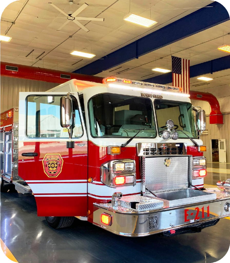
TRANSPORTATION & MOBILITY
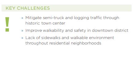
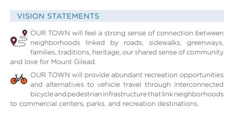
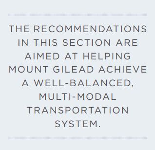
Mount Gilead’s transportation system is comprised of its roads, rail, bike, pedestrian, and transit networks, as well as access to air travel. Mount Gilead primarily relies on its road network to meet most transportation needs. However, the rail line plays an important role transporting industrial freight to market.The Town’s growing sidewalk network is well utilized and contributes to overall quality of life. The recommendations in this section
are aimed at helping Mount Gilead achieve a well-balanced, multi-modal transportation system. Mount Gilead maintains 11 miles of streets while the North Carolina Department of Transportation maintains the major state highways that connect the Town with the rest of the state. The 2012 Montgomery County Comprehensive Transportation Plan is the primary guiding document that identifies NCDOT road, pedestrian, and bicycle improvements in and surrounding Mount Gilead. For more than 130 years, Mount Gilead’s railroad has provided a direct connection to regional markets across the Piedmont. What began as the Aberdeen and Asheboro Railroad in the 1890s, is now the Aberdeen and Western Carolina short line freight railway operated by Norfolk
Southern. The line is active today, hauling lumber, forest products, agricultural products, and other goods manufactured in Mount Gilead to markets in Charlotte and beyond. Jordan Airfield is a private-use grassed airstrip, owned and primarily used by Jordan Lumber. Montgomery, Stanly, and Anson Counties all operate small public airports with asphalt runways within 15-20 miles of Mount Gilead. The Regional Coordinated Area Transportation System (RCATS) provides the only public transportation service in Montgomery County. Curb-to-curb transportation services for older adults, persons with disabilities, and the general public are provided on a county-wide basis. Montgomery County residents in need of transportation can make an advance reservation for Transportation medical appointments Monday-Friday and grocery shopping on Thursday morning. Alternative transportation options such as rideshare services (Uber and Lyft) are extremely limited in Montgomery County and currently do not provide a reliable option for transportation. The Town boasts a strong and growing pedestrian network in its commercial center that extends outward to many neighborhoods. The Town has made progress in filling sidewalk gaps and must continue prioritizing such connections to all Mount Gilead neighborhoods. Bicycle infrastructure is extremely limited, although NC State Bicycle Route 6 bisects the Town via Highway 731. Expanding bicycle and pedestrian infrastructure is one of the most strategic investments the town can make to enhance quality of life, improve community health, expand equity in transportation, and encourage vibrant streetscapes both downtown and throughout neighborhoods. Connectivity and culture thrive hand in hand.
POLICY GOALS & RECOMMENDATIONS
- Perform pedestrian-oriented streetscape improvements in downtown and at
small business growth areas.
1.1 Work with NCDOT to identify and provide signage for preferred semitruck routes that bypass the downtown.
1.2 Pursue grant funding through NCDOT for a bicycle and pedestrian plan
that identifies and prioritizes sidewalk gaps and bike infrastructure
projects.
1.3 Continue filling sidewalk gaps identified for Mount Gilead in the
Montgomery County Comprehensive Transportation Plan.
1.4 Coordinate with NCDOT’s R-5826 project to include streetscape
improvements at the intersection of Main Street & Allenton Street, such as
installing crosswalks and pedestrian signalization.
1.5 Contract with a design firm to update and develop construction
documents for downtown streetscape improvements based on the 2007
plan

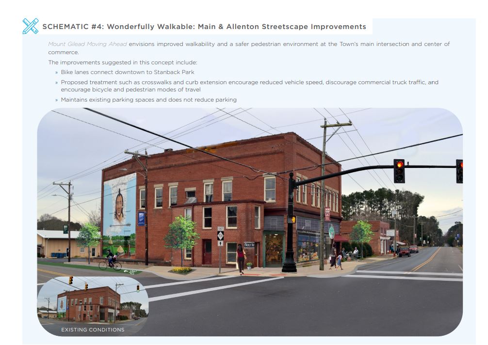
- Increase access to transportation options for citizens with mobility and independent living challenges.
2.1 Support RCATS and seek public & private funding for
the expansion of services:
2.1.1 Extend service hours from to 5:30pm to
accommodate afternoon medical appointments
and employment commutes.
2.1.2 Establish shuttle routes in Montgomery County
between Mount Gilead, Troy, Biscoe, and Star.
2.1.3 Increase staff and fleet capacity to include more
available drivers to accommodate next-day rider
reservations and emergency trips.
2.1.4 Increase the number of round-trips that a rider
can use per week (current limit is 3/week).
2.1.5 Develop mobile application and/or online portal
for making ride reservations.
2.1.6 Increase targeted marketing and communication
of services in English and Spanish to populations
in need.
2.2 Explore partnerships with private transportation
providers to fill service gaps.
- Improve appearance and flow of major thoroughfares and
roads.
3.1 Limit driveway cuts on highways and collector roads:
3.1.1 Set a minimum distance between driveways.
3.1.2 Set a maximum number of driveway cuts allowed
per lot.
3.1.3 Require interior vehicle connections between
businesses and buildings.
3.2 Concentrate commercial development density at
strategic locations along major corridors, while limiting
highway access along intervening stretches of road.
3.3 Develop Streetscape Corridor plans for the following
highway corridors. Plans should address potential for
road diets, multi-use paths, center medians, and street
trees to make them more appealing for commerce and
walkability.
» NC Hwy. 731 (E. Allenton Street) from Main Street to
the town limits
» NC Hwy. 109 (Julius Chambers Avenue) from N. Main
Street to the town limits
» N. Main Street from NC Hwy. 109 to Ingram Street
3.4 Adopt the NC Complete Streets Manual and amend
Street Design Standards in the Zoning Ordinance
to include preference for Complete Streets where
practicable.
CASE STUDY #13: When Money Grows on Trees: Street Trees as Economic Development
Street trees and landscaping help separate pedestrians from motor vehicle
traffic. Trees and plantings also provide interest by framing the street, softening the
appearance of hard surfaces and providing color, fragrance, and seasonal decor. They
also provide shade and areas of refuge for pedestrians. Street trees enhance the
pedestrian experience, increasing foot-traffic and encouraging downtown visitors
to stay long. More people spending more time on Main Street means a vibrant
streetscape and increased sales for local businesses. The NC Forest Service provides
grants on an annual basis to local governments for establishing or enhancing the
urban canopy with street-trees.
- Provide and promote walking and bicycle infrastructure for a safe alternative to
vehicle travel.
4.1 Establish a community organization to focus on planning and
implementing bicycle and pedestrian infrastructure, including greenways.
4.2 Leverage the Indian Heritage Trail Scenic Byway and the scenic rural roads
around Mount Gilead to develop bicycle tourism.
4.2.1 Promote road cycling as an outdoor recreation activity in Mount
Gilead.
4.2.2 Work with NCDOT and Montgomery County to install cycling lanes
& signage on the Indian Heritage Trail Scenic Byway, State Bicycle
Route 6, and the Route 5 loop identified on the 2005 Montgomery
County Bike Plan in the Piedmont Triad Regional Council RPO
Bicycle Study and the Montgomery County Comprehensive
Transportation Plan.
4.3 Connect community destinations such as schools, parks, and major
employers via greenways and trails.
4.3.1 Amend Zoning Ordinance to require that all new development
must include the installation of bicycle amenities, such as racks and
storage facilities.
4.3.2 Amend Zoning Ordinance Article 6 to require new development
to construct pedestrian or multi-use connections to adjacent
commercial areas, neighborhoods, and parks.
4.3.3 Install bike racks, storage, and maintenance stands in downtown
and at public parks to accommodate cycling and to signal support
for bicycles as a valid and encouraged form of transportation.
4.3.4 Establish a bike-loan or earn-a-bike program and community
bicycle shop operated by a parks and recreation entity or non-profit
organization. - Actively participate in the Piedmont-Triad Regional Council Rural Planning
transportation planning process to facilitate transportation projects in
alignment with this plan.
5.1 Maintain consistent attendance at meetings and representation in the
RPO planning process to ensure that Mt. Gilead transportation projects,
including bicycle & pedestrian, are prioritized in the State Transportation
Improvement Plan.
CASE STUDY #14: Building “Bikequity” at the Durham Bike Co-op
Bicycles have the power to make our local communities a better place as an
environmentally-friendly and socially-just transportation mode, a basis for community,
and a means to health and wellness. Bicycle cooperatives provide a way for all
members of the community to have access to a bicycle regardless of financial means.
For example, the Durham Bike Co-op is a nonprofit entity that operates an earn-a-bike
program whereby community members can earn a bicycle through volunteer hours.
The co-op also provides repair services, tools, storage space, and training to help
members learn how to fix bikes. Individuals must be members to have their bicycle
repaired at the co-op, with yearly membership earned through either a $30 donation
or 3 hours of volunteering. The repair shop is run by volunteer members who work
with donated bicycles and donated parts. Volunteers work in different capacities in
the shop while it is managed by democratically elected board members who serve
short terms and are also members themselves. Through volunteer engagement, the
Durham Bike Co-op offers a community space for individuals to learn and build new
skills while accessing reasonably priced resources.

PARKS & RECREATION
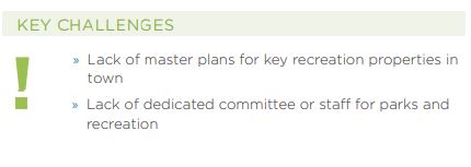
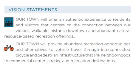
Mount Gilead benefits from an abundance of recreation resources both within and surrounding the town. While the Town does not have a parks and recreation department or formal staff position, it does maintain two
park facilities. The most notable is Stanback Park which features a public swimming pool, large playground, picnic pavilion, basketball court, tennis courts, baseball fields, pickleball courts, and plenty of space for unprogrammed and passive recreation. In the summer, the Town partners with Montgomery County to provide a six-week youth recreation day camp at Stanback Park. Mount Gilead’s other park properties include
the Walking Track at the Shankle Property and the future Albert Johnson Pocket Park on Main Street. The privately owned and operated Ralph J. Thompson Soccer Complex offers a popular youth soccer program for area residents. In addition to its traditional parks, Mount Gilead is strategically located a short drive from the Uwharrie National Forest, Lake Tillery, and the Pee Dee River which attract visitors and outdoor recreation tourists from across the state and region. With 74 miles of trails and 47,401 acres of public land and open space, Montgomery County stands head and shoulders above other counties in the Piedmont region when it
comes to the quantity of opportunities for outdoor recreation. Outdoor Recreation is a key element of the new economy for Mount Gilead. As a small town in a rural county striving to attract investment, tourism, young families, professionals, and retirees, Mount Gilead must continue to create accessible trails and greenways, inviting parks, and connectivity to its abundant public lands and water resources. Recreation is not merely a quality of life amenity, but a critical component of the Towns’ economic development strategy.
POLICY GOALS & RECOMMENDATIONS
- Improve quality of parks and recreation fields and facilities.
1.1 Develop Parks and Recreation Master Plan for capital improvements of
town-owned open space.
1.2 Construct the Albert Johnson Memorial Park according to the 2020 site
plan.
1.3 Develop a plan for a new town park at the Shankle property adjacent to
Mt. Gilead Elementary School.
1.4 Develop a joint-use and maintenance agreement with Montgomery
County Schools to enable public use and ensure routine maintenance of
basketball courts adjacent to Mount Gilead Elementary.
1.5 Develop a master plan for Stanback Park that will be competitive for a
Parks and Recreation Trust Fund grant to finance proposed improvements.
The plan should consider the following:
1.5.1 Convert Park Avenue to a north-bound one-way street and multiuse greenway in the southbound (park-adjacent) lane.
1.5.2 Restore natural creek-flow through center of park as an attractive
landscape feature and natural play-area.
1.6 Consider banning smoking in public parks and civic spaces to ensure
an enjoyable, healthy, and family-friendly environment. Install signage to
discourage smoking in these areas.
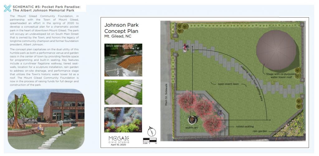
Public sentiment throughout the planning process expressed a desire to develop the Town-owned Shankle Property adjacent to Mount Gilead Elementary School into a destination community park. The concept illustrated here establishes the Shankle Property as the “Town Green” and a true community gathering space and performance venue in the center of Town. Recreation amenities complement the existing walking
track and provide additional play opportunities for elementary school students.
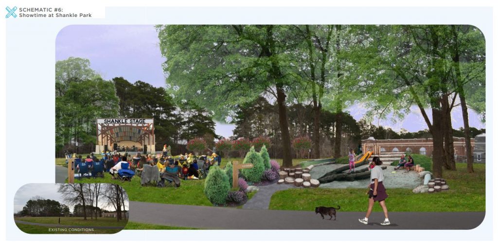
SCHEMATIC #6:
Showtime at Shankle Park
Public sentiment throughout the planning process expressed a desire to develop the Town-owned Shankle Property adjacent to Mount Gilead Elementary School into a destination community park. The concept illustrated here establishes the Shankle Property as the “Town Green” and a true community gathering space and performance venue in the center of Town. Recreation amenities complement the existing walking track and provide additional play opportunities for elementary school students.
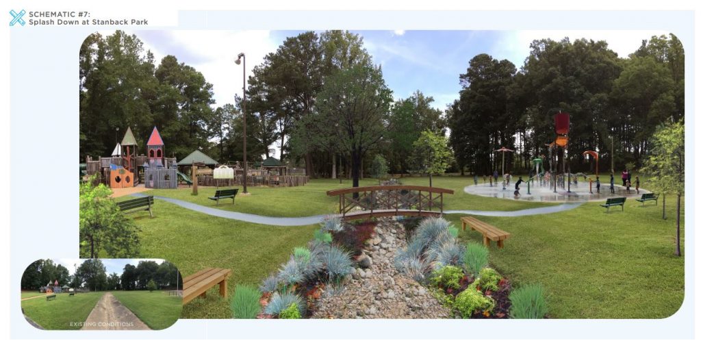
Stanback Park is a tremendous asset to the Mount Gilead community. The 26-acre park offers multiple amenities including a public swimming pool. The park is primed for updates and improvements to its existing infrastructure. If supported by a park master plan, Stanback Park could be highly competitive for grants, including a North Carolina Parks and Recreation Trust Fund grant, to fund destination-quality improvements such as a splash pad.
CASE STUDY #15: From Main Street to the Mountains: Connecting downtown to the National Forest in
Brevard, NC
Brevard, NC is working with local foundations and agencies to secure grant funding for the Estatoe Trail that connects its downtown to the nearby Pisgah National Forest. The City and its partners have been successful in building 4.8 miles of a natural surface greenway trail that extends from Davidson River campground in Pisgah National Forest to Brevard College, just north of downtown. In recent years, the City secured $90,000 in funding from the Parks and Recreation Trust Fund (PARTF) and
$240,000 in funding from the Pisgah Health Foundation to extend the Estatoe Trail to Brevard’s historically Black neighborhood, Rosenwald, and its downtown district. The greenway provides a critical connection between the city’s two most important economic engines: the central business district and outdoor recreation in Pisgah National Forest.
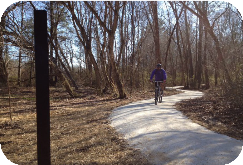
- Strengthen relationships and support for civic organizations that maintain park facilities and manage programming efforts to ensure continued operations that are fiscally sustainable.
2.1 Reinstate the Parks and Recreation
Commission or hire a part-time Parks
and Recreation Director that could
eventually transition to a full-time
employee.
2.2 Partner with Highland Community
Center to develop the outer property
at the community center for
recreation such as multi-use sports
fields and a walking trail.
2.3 Evaluate fiscal sustainability of
Stanback Park Summer Program
and pursue fundraising strategies to
ensure continuation of the program at
low cost to local participants. - Connect Mt. Gilead’s recreation assets via greenways and trails.
3.1 Develop a greenway master plan that
will connect downtown Mount Gilead
to the Uwharrie National Forest, Lake
Tillery, and other key destinations.
3.2 Participate in future updates to the
Piedmont Triad Regional Trail Plan
& Inventory to advocate for the
inclusion & prioritization of trails &
blueways near Mount Gilead.
3.3 Advocate for development of multiuse path 8F (Uwharrie National Forest
to Chatham Co.) as identified in the
North Carolina Great Trails State
Master Plan.
EXHIBIT #9: The Economic Case for Greenways
An interconnected network of greenways and trails is a powerful economic development tool. Trails and greenways impact local and regional economies by enhancing quality of life for residents, increasing nearby property values, lowering healthcare costs, and providing a venue for community events. Most significantly, greenways, trails, and sidewalks serve as the catalyst for stimulating private investment and recreation
tourism.
Greenways and trails stimulate small business development and private investment by attracting a new customer base. This new customer base increases consumer spending in existing businesses along the trail and also attracts new trail or greenway related businesses such as bicycle rental or a trailside café. As local businesses are patronized by trail users, they purchase supplies and services from manufacturers in other sectors of the economy, thereby multiplying the impact of the trail throughout the county.
The boost to local economies provided by trails and greenways is considerable. A 3-year study of study of greenways by North Carolina State University (completed in 2018), found that for every $1.00 spent on trail construction, $1.72 were generated annually in local business revenue, sales tax revenue, and
benefits related to improved health & transportation. The study also reported that across the four greenways studied, 790 jobs were supported through trail construction. Similarly, an economic impact study of the Swamp Rabbit Trail in South Carolina found that the trail generated a $6.7 million dollar return on investment in its first three years. Residential properties located near a trail or greenway also benefit from a significant increase in property values. The greenway is an amenity that commands a higher price for nearby homes. The Little Miami Scenic Trail in Ohio is associated with higher property values up to one mile away from the trail. For every foot closer to the Little Miami trail, single-family home value increases by $7. Home values increase near trails because they are an attractive amenity to families and professionals looking to relocate. As a result, homes near greenways often sell faster. The National Association of Homebuilders states that “Trails consistently
remain the number one community amenity sought by prospective homeowners”
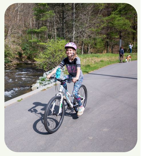
CASE STUDY #16: Empowering the Next Generation through “My Durham”
Youth Programs offer active programming to engage teens and pre-teens after school and during weekends. The “My Durham” program was designed by teenagers, for teenagers. By placing this authority with the teens who would be participating in the program, it ensures that activities and events are actually engaging and interesting to participants. The program is housed in two different locations in Durham: the Durham Teen Center at Lyon Park and the Weaver Street Recreation Center. These two centers offer a variety of resources any time of day including computer labs, gaming lounges, basketball and baseball, and more. The program is open for teens aged 13-18, runs Monday through Friday from 2:30-5:30 and is entirely free, offering a fantastic option for families to keep their teens engaged and active while out of the house during this time. Programming includes field trips, outdoor sports, healthy cooking classes, “Digital Brilliance Hour” where teens learn how to code their own computer games, video game tournaments, and encouraging youth to socialize and get to know the resources the city has to offer. By providing a safe space for youth to hang out, socialize, or get homework done, the My Durham youth program ensures engagement in new learning and community building from each generation of teens.

- Support existing programming and explore opportunities for new
programming that provides safe entertainment and recreation opportunities
for youth and young adults after school and in the evenings.
4.1 Work with the Mt. Gilead Library to develop innovative programming that
activates the library in the evenings and on weekends for pre-teens and
teens especially.
4.2 Partner with organizations like Highland Community Center and local
Churches to develop creative pre-teen and teen after-school and weekend
programming and safe hang-out spaces. - Improve public access to water-based recreation resources.
5.1 Work with Montgomery County, NC Wildlife Resources Commission, and
regional conservation organizations to conserve lakefront property around
Lake Tillery and plan for new public lake access.
5.2 Work with NC Wildlife Resources Commission and Duke Energy to
improve existing and create new recreational water access locations on
the Pee Dee River.
5.3 Urge Duke Energy and Alcoa Power Generating Inc. to better coordinate
dam releases to stabilize unpredictable lake levels and river flows.
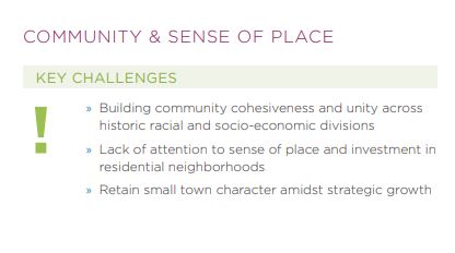
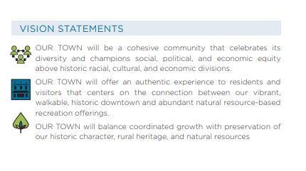
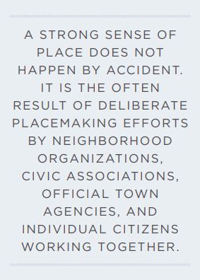
Mount Gilead’s distinct identity has developed over time as a result of its rich history, inspiring pastoral landscape, and the vibrant personalities of its people. Together, these elements often influence the built environment which, in turn, impacts everyday life as we interact with and navigate the network of roads, buildings, pathways, and places we’ve created. Whether we are aware of it or not, we often have an emotional association with a place, especially the places we frequent most. Mount Gilead has long evoked a distinctive sense of place in many people, as evidenced by its enduring heritage and the common sentiment among
newcomers that the Town and community “just feel like home.” Sense of Place is more than just a nice feeling; it translates to tangible economic impact by drawing people to town as a result of both the built environment and the vibrant energy of the community. This feeling is evident in the patina of a historic building, a lively farmers market, peaceful park, vibrant library, or an energetic school yard filled with laughter. Sense of Place is hard to measure, but critical to the sustained economic prosperity of a community. Streets, sidewalks, and parks full of activity represent the ability to sustain restaurants, local shops, the arts community, and dynamic third places like cafés and breweries. Tax revenue generated from downtown districts can help fund streetscape improvements and new amenities such as free WiFi. Mount Gilead’s diversity is one of its most outstanding community assets. Diversity of cultures, food, arts, languages, talents and abilities add to the vitality and resiliency of a community – making it stronger and more attractive to a wider variety of visitors, residents, and new business. A strong sense of place does not happen by accident. It is often the result of deliberate placemaking efforts by neighborhood organizations, civic associations, official town agencies, and individual citizens working together to make their community more livable and loveable.
POLICY GOALS & RECOMMENDATIONS
- Nurture a sense of place and community pride in Mt. Gilead.
1.1 Consider establishing a Mt. Gilead Beautification Committee to identify
and lead implementation of beautification initiatives throughout the town.
1.2 Develop a gateway signage system and work with private property
owners or NCDOT right-of-way to improve existing or establish consistent
recognizable gateways into Mt. Gilead by installing new signage,
landscaping, and street trees at or near the following intersections, in
order of priority:
» NC Hwy. 109 (Julius Chambers Avenue) and Williams Street
» NC Hwy. 731 (E. Allenton Street) and Six Pine Drive
» NC Hwy. 73 (N. Main Street) and PaperWorks driveway entrance
» NC Hwy. 731 (W. Allenton Street) and Tobe Manufacturing driveway
entrance
» NC Hwy. 73 (S. Main Street) and Medford Place
» NC Hwy. 109 (S. Wadesboro Boulevard) and Rance Lane
1.3 Cultivate pride of place in Mt. Gilead’s various distinct neighborhoods by
establishing a neighborhood sign program to install signs at the entrances
to each neighborhood.
1.4 Utilize minimum housing code to address residential decay, blighted
properties, and junked vehicles to increase safety, protect quality of life,
and property values.
1.5 Invest in streetscape infrastructure of legacy neighborhoods: Develop a
Town-administered program or partner with a local non-profit to establish
a neighborhood-based grant program that provides matching funding and
resources to blocks of individuals who want to improve the aesthetics and
performance of their neighborhood street.
1.6 Invest in downtown placemaking.
1.6.1 Install landscaping such as planter boxes and hanging baskets on
light posts to create an inviting pedestrian environment.
CASE STUDY #17: First Impressions: Making a Statement at Key Gateways
Consistent, recognizable gateway signage helps towns to establish a visual identity and convey a sense of arrival to the town as a desirable destination. The City of Locust recently installed a new gateway sign on Highway 24/27 to greet visitors and welcome locals returning to town at the western entrance. It was designed with natural characteristics in mind, featuring faux-stone supporting the eye-catching orange sign that includes the city’s name and slogan. The sign itself is surrounded by neat landscaping of plants encircled by a stone border. The project also features a solar powered light source to illuminate the sign at peak hours. The goal of the City Beautification Division that took on this project is to “make the City of Locust as appealing to the senses as possible.” With that in mind, this gateway signage certainly helps to welcome new visitors and those returning home all while demonstrating the city’s pride and attractiveness.
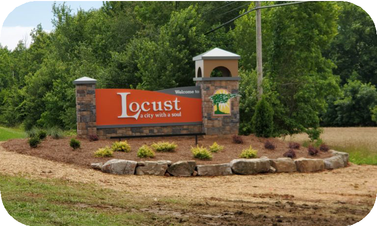
- Cultivate pride of place in Mt. Gilead’s various distinct neighborhoods by establishing a neighborhood sign program to install signs at the entrances to each neighborhood.

- Utilize minimum housing code to address residential decay, blighted properties, and junked vehicles to increase safety, protect quality of life, and property values.
- Invest in streetscape infrastructure of legacy neighborhoods: Develop a Town-administered program or partner with a local non-profit to establish a neighborhood-based grant program that provides matching funding and resources to blocks of individuals who want to improve the aesthetics and performance of their neighborhood street.
- Invest in downtown placemaking.
- Install landscaping such as planter boxes and hanging baskets on light posts to create an inviting pedestrian environment.
CASE STUDY #18: Grassroots Neighborhood
Revitalization with the Oswego Renaissance Association
Consistent, recognizable gateway signage helps towns to establish a visual identity and convey a sense of arrival to the town as a desirable destination. The City of Locust recently installed a new gateway sign on Highway 24/27 to greet visitors and welcome locals returning to town at the western entrance. It was designed with natural characteristics in mind, featuring faux stone supporting the eye-catching orange sign that includes the city’s name and slogan. The sign itself is surrounded by neat landscaping of plants encircled by a stone border. The project also features a solar powered light source to illuminate the sign at peak hours. The goal of the City Beautification Division that took on this project is to “make the City of Locust as appealing to the senses as possible.” With that in mind, this gateway signage certainly helps to welcome new visitors and those returning home all while demonstrating the city’s pride and attractiveness.
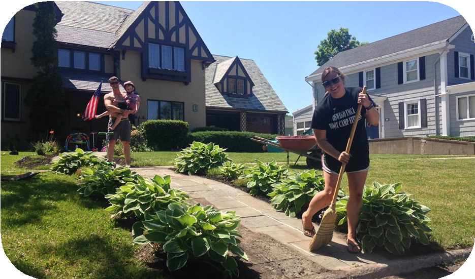
1.6.2 Separate existing parking lots from sidewalks in downtown by
installing decorative seat walls or planter boxes to enhance the
pedestrian experience.
1.6.3 Install street furniture such as seating and trash receptacles that
double as functional public art.

1.7 Cultivate the arts and cultural offerings in Mt. Gilead.
1.7.1 Encourage development of an arts council to facilitate cultural and
economic development through the arts in Mt. Gilead.
1.7.2 Develop a sculpture program for installing permanent or rotational
public art exhibits in key locations and destinations throughout Mt.
Gilead, such as the Albert Johnson Memorial Park.
1.7.3 Expand mural program to other areas of Mt. Gilead, including
creative applications like electrical boxes or stairs. Consider Percent
for Art program to fund commissions.
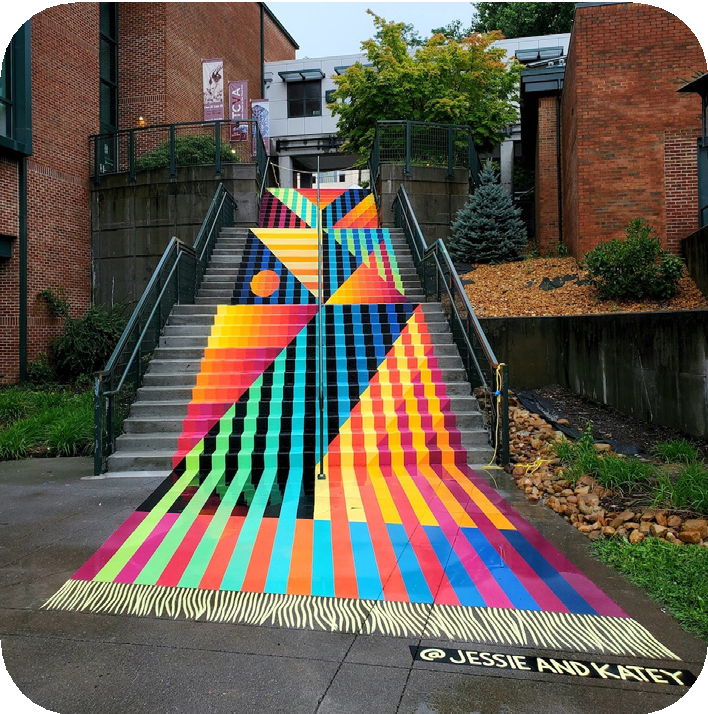
1.7.4 Host a monthly downtown art-crawl that highlights public art
installations, features local artists, and engages downtown
businesses.
1.8 Consider establishing a community garden and edible landscapes in
downtown planters.
1.9 Amend Zoning Ordinance to ensure that limitations on non-conforming
structures also apply to non-conforming signs.
- Celebrate the diversity of Mt. Gilead by encouraging multi-cultural, communitywide events that intentionally bring together populations with different racial,
cultural, and economic backgrounds.
2.1 Prioritize investment in festivals and events that highlight
underrepresented cultures and populations with a focus on uniting diverse
audiences from varying racial, ethnic, and socioeconomic backgrounds. - Provide community gathering and event space by investing in existing cultural
and community centers, and exploring locations to open new community
centers or offer new programming.
3.1 Continue investing and partnering with Highland Community Center.
Develop a master plan for the site and plan for improvements that will
allow the center to generate revenue.
3.2 Pursue new programming and uses for the Leah Levin Memorial
Auditorium such as an event space for public and private functions.
CASE STUDY #19: Friday Night Lights: Spotlight on Visual Arts in Boone, NC
Crawls invite the public to view local artists’ work in public art installations, galleries, or studios in a concentrated geographic area so that individuals get the chance to see a variety of art through the duration of the event. In Boone, the First Friday Art Crawl takes place along the downtown area’s King Street. Public art installations are featured at the local university’s Center for Visual Arts, as well as in local art cooperatives and shops. Local musicians participate in jam sessions at venues along the downtown area and perform at restaurants where art crawl visitors stay after to grab a meal. More formal concert series are also hosted at different venues downtown as well. Artists are able to gather engagement and make sales, and small businesses along the downtown area often stay open later and offer drinks and snacks to visitors. Many businesses also have unique offerings, such as raffles and giveaways or big sales. The popular event is marketed through social media, word of mouth in downtown businesses, and by posters hung throughout the community. The reliability and regularity of the event also ensures its success, as people are sure to find something exciting happening downtown every first Friday throughout the year, rain or shine.
3.3 Consider promoting the Mount Gilead Museum as an event space for
weddings, receptions, and corporate meetings to generate revenue for the
museum and bring visitors to the Town.
- Cultivate a town and community that is attractive to young families &
professionals in order to promote youth retention and encourage young
citizens who leave to return and invest in Mt. Gilead.
4.1 Provide affordable, reliable childcare options for working parents.
4.1.1 Partner with organizations like Highland Community Center and
local churches to explore opportunities to provide low-cost child
care programs during week days.
4.1.2 Incentivize new child care centers and redevelopment of existing
buildings for child care by offering a streamlined zoning process,
reduced application fees, and reduced minimum parking standards.
4.1.3 Partner with commercial property owners with an appropriate,
available space to recruit child care businesses.
4.1.4 Work with local non-profit organizations and churches to establish a
scholarship program to subsidize child-care for low-income working
parents.
4.2 Instill a sense of community ownership and youth participation by
recruiting younger citizens to engage and volunteer in community events
and organizations. Consider re-establishing the Mount Gilead Youth
Council or include high school student representatives on key appointed
boards and committees responsible for hosting community events.
4.3 Work with Montgomery County Schools, local industries, and businesses
to establish an internship/apprenticeship program for Mt. Gilead high
school students enrolled in Career & Technical Course Pathways. - Allow older generations to age in place with grace and dignity.
5.1 Support expansion of existing senior programs at Highland Community
Center and local churches.
5.2 Supplement Montgomery County senior services by encouraging mealdelivery programs, in-home chores & handy-work assistance programs,
and wellness check programs by local organizations and volunteers.
CHAPTER OVERVIEW
Mount Gilead Moving Ahead: Our Town 2040 provides a wide-ranging policy
framework to guide decision-making across all levels of community action
from Town government to civic-minded individuals spearheading a specific
project.
The true impact of Mount Gilead Moving Ahead: Our Town 2040 will come from the
accomplishing the policy goals and many strategies identified in the plan to achieve
the community’s ultimate vision for Mount Gilead. Investment in Mount Gilead’s
collective future must continue with a renewed commitment by Town staff, elected
officials, appointed board members, and the community at large – all working in
harmony to improve the Town they love.
This chapter is comprised of several Implementation Matrices. The first six (6) matrices
correspond with each Planning Element and identify priority recommendations
within each element. Each matrix identifies the coordinating agencies responsible for
leading the implementation of each priority recommendation as well as the timeframe
for completing priority recommendations as either short term, mid-term, long term,
or continuous.
» Short-term: achievable in less than two years
» Mid-term: achievable in 2-5 years
» Long-term: may take more than 5 years
» Continuous: ongoing efforts
This chapter also includes a matrix that organizes all recommendations related to
Downtown Mount Gilead. A reference list of all Visible Victories is included, as well.
PLAN MAINTENANCE
Planning for community success and vitality never stops. Town staff should continuously monitor progress toward achieving the plan’s vision and goals. Town staff, the Planning Board and Board of Commissioners should review progress on plan implementation each year as part of the Town’s budget retreat. This practice will give the Board of Commissioners the opportunity to establish implementation priorities during each budget cycle in order to ensure that the Town’s budget includes the necessary resources to move forward with the implementation priorities.
Mount Gilead Moving Ahead: Our Town 2040 should be fully updated every five (5) years and adjusted in response to shifting challenges, new opportunities, changes in the economic and social needs of the community, emerging technology, and the advent of new best practices in community planning. Citizen voices should always be a part of the conversation.
IMPLEMENTATION MATRICES
LAND USE AND ENVIRONMENT
|
PRIORITY RANKING |
RECOMMENDATION |
COORDINATING AGENCIES |
TIMEFRAME |
|
1 |
1.1 Amend Zoning Ordinance for consistency with the 2040 Future Land Use Map and recommendations of Mt. Gilead Moving Ahead . |
Town Staff, Planning Board, & Town Commissioners |
Short Term |
|
2 |
1.2 Adopt Conservation Cluster Development standards to encourage smart growth and open space preservation. |
Town Staff, Planning Board, & Town Commissioners |
Short Term |
|
3 |
1.4 Amend Town ordinances to require annexation for all new development around Lake Tillery that desires public sewer service from Mt. Gilead. Require conservation cluster development as conditions of service in order to conserve the natural aesthetic of Lake Tillery and maintain efficient extension of necessary infrastructure. |
Town Staff, Planning Board, & Town Commissioners |
Short Term |
|
4 |
2.6 Amend Zoning Ordinance to allow manufactured housing by right in the ETJ with lot requirements and design standards to protect existing rural residential character. |
Town Staff, Planning Board, & Town Commissioners |
Short Term |
|
5 |
3.1 Protect rural and residential character by adopting commercial design standards for highway corridors that prohibit strip-style linear development and corporate architecture that does not contribute to the traditional vernacular of the town. |
Town Staff, Planning Board, & Town Commissioners |
Mid-Term |
|
6 |
4.1 Continue protecting historic architecture by enforcing both the National Register Historic District Standards and the Downtown Historic District Guidelines in their respective districts and requiring Certificates of Appropriateness for proposed modifications to buildings. |
Town Staff, Main Street Advisory Board, Historic Preservation Commission |
Ongoing |
|
7 |
7.1 Partner with Montgomery County to develop a Strategic Land Use Plan for Lake Tillery aimed at smart growth that conserves the natural and aesthetic value of the lake and provides for new public access and recreation locations. |
Town Staff, Montgomery County Staff |
Mid-Term |
|
8 |
5.1 Transition Zoning Ordinance toward a form-based code that prioritizes regulation of the physical form of development (scale, mass, type of buildings and streets) more than separation of uses. |
Town Staff, Planning Board, & Town Commissioners |
Long Term |
|
9 |
2.7 Allow attached or detached accessory dwelling units in all residential districts by right.. |
Town Staff, Planning Board, & Town Commissioners |
Short Term |
|
10 |
7.2 Work with Montgomery County, Three Rivers Land Trust, and the NC Wildlife Resources Commission to prevent total privatization and development of the lakeshore by conserving lakefront property for public access & low-impact recreation tourism. |
Town Staff, Three Rivers Land Trust, NC Wildlife, Montgomery County Staff |
Long Term |
ECONOMIC PROSPERITY
|
PRIORITY RANKING |
RECOMMENDATION |
COORDINATING AGENCIES |
TIMEFRAME |
|
1 |
3.4.8 Scale zoning and development permit fees by project size so that fees are proportionate to the size and cost of the project. |
Town Staff, Planning Board, & Town Commissioners |
Short Term |
|
2 |
3.3.1 Work with property owners with available land in targeted growth areas (Sectors 4, 5, 6) to develop a strategy for commercial recruitment. |
Town Staff, Local Property Owners, & Developers, Montgomery County Economic Development |
Ongoing |
|
3 |
3.6 Publish and promote an inventory of available industrial properties in Sector 5. |
Town Staff, Montgomery County Economic Development |
Short Term |
|
4 |
4. Increase socioeconomic mobility by expanding accessibility to broadband internet. |
Town Staff, Montgomery County Schools & Community College, Highland Community Center |
Mid-Term |
|
5 |
3.5 Attract new lodging business to support the tourism industry. |
Town Staff, Local Property Owners, & Developers, Montgomery County Economic Development |
Ongoing |
|
6 |
3.1 Request assistance from the NC Main Street Rural Planning Program to develop a Five-year Strategic Plan for the Mt. Gilead Redevelopment Corporation. Include strategies for expanding operations to include broader economic development tasks such as marketing, business recruitment, small business support, and property acquisition for redevelopment. |
Mt. Gilead Revelopment Corporation Board, Town Staff, NC Main Street |
Mid-Term |
|
7 |
3.4.2 Establish a dedicated business incubator space in the Piedmont Arts Center that fosters innovative start-ups, young businesses, artisans, and minority-owned businesses. Consider renaming this building to appeal to a broader range of entrepreneurs. |
Mt. Gilead Revelopment Corporation Board, Town Staff |
Long Term |
|
8 |
1.1 Implement a distinct & recognizable visual brand for the Town. |
Town Staff, Brand Steering Committee, Private Consultant |
Mid-Term |
|
9 |
1.4 Redevelop the Town website based on target market research and key messaging about Mt. Gilead’s downtown & outdoor recreation assets. |
Town Staff, Private Consultant |
Short Term |
|
10 |
2.2 Install wayfinding signage from nearby recreation destinations to Downtown Mt. Gilead. |
Town Staff, Civic Organizations, Private Consultant |
Mid-Term |
INFRASTRUCTURE & SERVICES
|
PRIORITY RANKING |
RECOMMENDATION |
COORDINATING AGENCIES |
TIMEFRAME |
|
1 |
1.1 Continue implementation of the Town’s 20-Year Capital Improvement Plan for water and sewer infrastructure to plan for replacement of aging water and sewer infrastructure, prioritizing targeted growth areas (Sectors 4, 5, 6). |
Town Staff |
Ongoing |
|
2 |
1.2 Update inventory of water and sewer lines and facilities to systematically prioritize upgrades. |
Town Staff, Private Consultant |
Mid-Term |
|
3 |
1.4 Coordinate with Montgomery County Planning to manage residential growth around Lake Tillery to ensure that development doesn’t outpace water and sewer infrastructure. |
Town Staff, Montgomery County Staff |
Ongoing |
|
4 |
1.5 Review the 2007 Utility Allocation and Extension Policy to require that new development must connect to the Town’s water system at the expense of the developer if it is within a reasonable distance from an existing water main. Continue extension policies that ensure that the cost of growth is not borne by existing water customers. |
Town Staff, Town Commissioners |
Short Term |
|
5 |
1.6 Any Town-initiated expansion of utilities shall reinforce targeted growth sectors (4, 5, & 6) for increased development densities. |
Town Staff, Planning Board, Town Commissioners |
Ongoing |
|
6 |
3.1 Conduct study of peer cities & towns to identify improvements that can be made to employee benefits packages. |
Town Staff, Private Consultant |
Mid-Term |
|
7 |
5.1 Conduct a Needs Analysis and Cost Analysis to evaluate the need for space and the capital required to improve the current Town Hall or construct a new one. |
Town Staff, Private Consultant |
Mid-Term |
|
8 |
4.2 Work with Montgomery County to evaluate solutions for equitable distribution of fire-tax revenue to each fire district based on need rather than property value. |
Town Staff, Montgomery County Staff |
Mid-Term |
|
9 |
1.3. Pursue USDA loan funding and grants to facilitate replacement of aging water and sewer infrastructure. |
Town Staff |
Ongoing |
|
10 |
4.1.1 Work with Montgomery County to evaluate and plan for phased implementation of paid fire department positions. |
Town Staff, Montgomery County Staff |
Long Term |
TRANSPORTATION & MOBILITY
|
PRIORITY RANKING |
RECOMMENDATION |
COORDINATING AGENCIES |
TIMEFRAME |
|
1 |
1.4 Coordinate with NCDOT’s R-5826 project to include streetscape improvements at the intersection of Main St. & Allenton St. such as installing crosswalks and pedestrian signalization. |
Town Staff, NCDOT, Piedmont Triad RPO |
Mid-Term |
|
2 |
1.1 Work with NCDOT to identify and provide signage for preferred semi-truck routes that bypass the down |
town.Town Staff, NCDOT |
Short Term |
|
3 |
1.2 Pursue grant funding through NCDOT for a bicycle and pedestrian plan that identifies and prioritizes sidewalk gaps and bike infrastructure projects. |
Town Staff, NCDOT, Piedmont Triad RPO |
Short Term |
|
4 |
4.1 Establish a community organization to focus on planning and implementing bicycle and pedestrian infrastructure, including greenways. |
Town Staff, Town Commissioners |
Mid-Term |
|
5 |
4.3 Connect community destinations such as schools, parks, and major employers via greenways and trails. |
Town Staff, NCDOT, Piedmont Triad RPO, Property Owners, Private Consultant |
Ongoing |
|
6 |
1.3 Continue filling sidewalk gaps identified for Mt. Gilead in the Montgomery County Comprehensive Transportation Plan. |
Town Staff, NCDOT |
Ongoing |
|
7 |
3.3 Develop Streetscape Corridor plans for specified highway corridors. Plans should address potential for road diets, multi-use paths, center medians, and street trees to make them more appealing for commerce and walkability. |
Town Staff, NCDOT, Private Consultant |
Long Term |
|
8 |
3.1 Amend development ordinances to limit driveway cuts on highways and collector roads. |
Town Staff, Planning Board, Town Commissioners |
Short Term |
|
9 |
1.5 Contract with a design firm to update and develop construction documents for downtown streetscape improvements based on the 2007 plan. |
Town Staff, Private Consultant, NCDOT |
Mid Term |
|
10 |
5.1. Maintain consistent attendance at meetings and representation in the RPO planning process to ensure that Mt. Gilead transportation projects, including bicycle & pedestrian, are prioritized in the State Transportation Improvement Plan. |
Town Staff, Town Commissioners |
Ongoing |
PARKS & RECREATION
|
PRIORITY RANKING |
RECOMMENDATION |
COORDINATING AGENCIES |
TIMEFRAME |
|
1 |
1.1 Develop Parks and Recreation Master Plan for capital improvements of town-owned open space. |
Town Staff, Private Consultant |
Mid-Term |
|
2 |
3.1 Develop a greenway master plan that will connect downtown Mt. Gilead to the Uwharrie National Forest, Lake Tillery, and other key destinations. |
Town Staff, Private Consultant |
Mid-Term |
|
3 |
2.3 Evaluate fiscal sustainability of Stanback Park Summer Program and pursue fundraising strategies to ensure continuation of the program at low cost to local participants. |
Town Staff, Montgomery Countuy Staff, Community Partners |
Short Term |
|
4 |
2.1 Reinstate the Parks and Recreation Commission or hire a part-time Parks and Recreation Director that could eventually transition to a full-time employee. |
Town Staff, Town Commissioners |
Mid-Term |
|
5 |
1.2 Construct the Albert Johnson Memorial Park according to the 2020 site plan. |
Town Staff, Mt. Gilead Community Foundation, Private Consultant |
Long Term |
|
6 |
1.3 Develop a site-specific plan for a new town park at the Shankle property adjacent to Mt. Gilead Elementary School. |
Town Staff, Private Consultant |
Mid-Term |
|
7 |
1.5 Develop a master plan for Stanback Park that will be competitive for a Parks and Recreation Trust Fund grant to finance proposed improvements. |
Town Staff, Private Consultant |
Mid-Term |
|
8 |
2.2 Partner with Highland Community Center to develop the outer property at the community center for recreation such as multi-use sports fields and a walking trail. |
Town Staff, Highland Community Center, Private Consultant |
Mid-Term |
|
9 |
1.4 Develop a joint-use and maintenance agreement with Montgomery County Schools to enable public use and ensure routine maintenance of basketball courts adjacent to Mount Gilead Elementary. |
Town Staff, Montgomery County Schools |
Short Term |
|
10 |
4.2 Partner with organizations like Highland Community Center and local Churches to develop creative pre- teen and teen after-school and weekend programming and safe hang-out spaces. |
Town Staff, Highland Community Center, Local Churches, Civic Organizations |
Mid-Term |
COMMUNITY DEVELOPMENT & PLACEMAKING
|
PRIORITY RANKING |
RECOMMENDATION |
COORDINATING AGENCIES |
TIMEFRAME |
|
1 |
1.4 Utilize minimum housing code to address residential decay, blighted properties, and junked vehicles to increase safety, protect quality of life, and property values. |
Town Staff, Code Enforcement Contractor |
Ongoing |
|
2 |
1.9 Amend Zoning Ordinance to ensure that limitations on non-conforming structures also apply to non- conforming signs. |
Town Staff, Planning Board, Town Commissioners |
Short Term |
|
3 |
3.1 Continue investing and partnering with Highland Community Center. Develop a master plan for the site and plan for improvements that will allow the center to generate revenue. |
Town Staff, Highland Community Center, Private Consultant |
Mid-Term |
|
4 |
4.1 Provide affordable, reliable childcare options for working parents. |
Town Staff, Highland Community Center, Churches, Other Community Organizations, Private |
Long Term |
|
5 |
1.7.1 Encourage development of an arts council to facilitate cultural and economic development through the arts in Mt. Gilead. |
Town Staff, Town Commissioners |
Mid-Term |
|
6 |
1.6.1 Install landscaping such as planter boxes and hanging baskets on light posts to create an inviting pedestrian environment. |
Town Staff, Main Street Advisory Board |
Mid-Term |
|
7 |
1.6.3 Install street furniture such as seating and trash receptacles that double as functional public art. |
Town Staff, Main Street Advisory Board |
Mid-Term |
|
8 |
1.2 Develop a gateway signage system and work with private property owners or NCDOT right-of-way to improve existing or establish consistent recognizable gateways into Mt. Gilead by installing new signage, landscaping, and street trees at identified intersections. |
Town Staff, NCDOT, Private Consultant |
Mid-Term |
|
9 |
1.1 Consider establishing a Mt. Gilead Beautification Committee to identify and lead implementation of beautification initiatives throughout the town. |
Town Staff, Town Commissioners |
Mid-Term |
|
10 |
3.2 Pursue new programming and uses for the Leah Levin Memorial Auditorium such as an event space for public and private functions. |
Town Staff, Town Commissioners, Community Organizations |
Mid-Term |
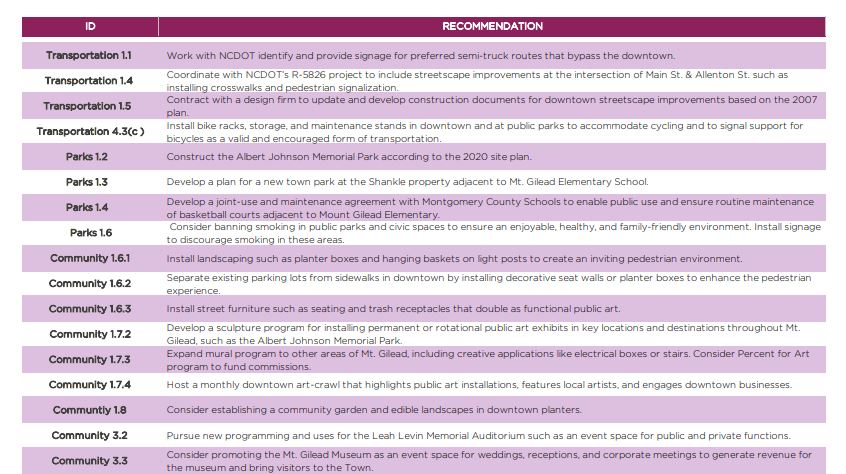
SUMMARY OF VISIBLE VICTORIES
Visible Victories are short-term recommendations that can begin immediate implementation to achieve visible and tangible results in support of the long-term vision for Mount Gilead. This list summarizes the Visible Victories identified throughout Chapter 3: Recommendations.
» Implement a distinct & recognizable visual brand for the Town.
» Install wayfinding signage from nearby recreation destinations to Downtown Mt. Gilead.
» Re-establish a consistent community farmers market in downtown Mt. Gilead.
» Work with Market Montgomery Chamber of Commerce & Tourism to develop and implement targeted social media campaigns that highlight Mt. Gilead businesses.
» Amend Zoning Ordinance to allow and encourage outdoor patio seating and dining in downtown and on sidewalks with adequate width.
» Consider hosting new non-traditional festivals and recurring monthly events downtown, such as a food truck rodeo.
» Consider a facility rental program that will allow the Mt. Gilead Fire Department to generate revenue as a community center and venue space for public and private events.
» Install bike racks, storage, and maintenance stands in downtown and at public parks to accommodate cycling and to signal support for bicycles as a valid and encouraged form of transportation.
» Develop a joint-use and maintenance agreement with Montgomery County Schools to enable public use and ensure routine maintenance of basketball courts adjacent to Mount Gilead Elementary
» Consider banning smoking in public parks and civic spaces to ensure an enjoyable, healthy, and family-friendly environment. Install signage to discourage smoking in these areas.
» Develop a gateway signage system and work with private property owners or NCDOT right-of-way to improve existing or establish consistent recognizable gateways into Mt. Gilead by installing new signage, landscaping, and street trees at key gateways.
» Cultivate pride of place in Mt. Gilead’s various distinct neighborhoods by establishing a neighborhood sign program to install signs at the entrances to each neighborhood.
» Install landscaping such as planter boxes and hanging baskets on light posts to create an inviting pedestrian environment.
» Install street furniture such as seating and trash receptacles that double as functional public art.
» Expand mural program to other areas of Mt. Gilead, including creative applications like electrical boxes or stairs. Consider Percent for Art program to fund commissions.
» Host a monthly downtown art-crawl that highlights public art installations, features local artists, and engages downtown businesses.
» Consider establishing a community garden and edible landscapes in downtown planters.
» Consider promoting the Mt. Gilead Museum as an event space for weddings, receptions, and corporate meetings to generate revenue for the museum and bring visitors to the Town.